|
|
|
 |
The History of Crooke Village
The images below are used with the permission of Wigan Archives Service, no part of these images may be reproduced
without the prior permission of Wigan Heritage Services. Every effort has been made to ensure that Wigan Archive images
are displayed fairly, and not in breach of copyright. If you have any concerns, please contact the Archives. Further details
about the Wigan Archives Photographic Collection and obtaining copies of images can be found at
http://www.wlct.org/Culture/Heritage/heritage.htm"
In late January of 2013, I was handed some fresh information about the goings on in and around Crooke between 1800 and 1900.
With this in mind, I have made alterations to the input of this page and as a result, I hope it will make a more interesting read?
I must point out that there may be slight date differences of events but I will try to be as accurate with my dating as possible.
If, when I have completed my alterations and you think a date I have submitted to be incorrect, I invite you to contact me to
discuss any such issue so that it can be resolved. So this is my re-write of Crooke History.
As a precursor to me telling you about the village history, I came across this document which precis's those history details. It
reads:-
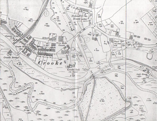
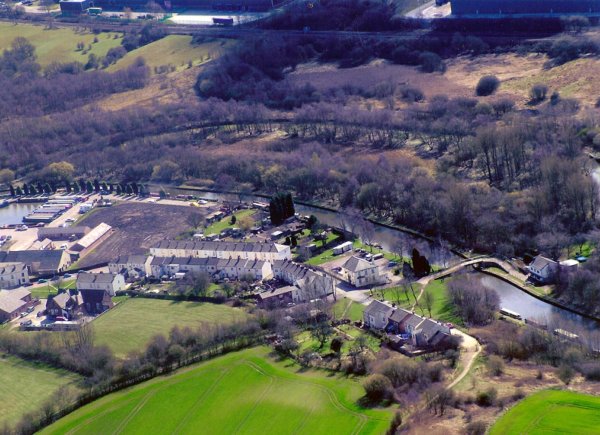
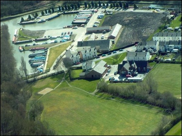
Residentially, Crooke is one of Wigan's best kept secrets. It is the beautiful and traditional little village of Crooke which
nudges up to Standish Lower Ground. There are a couple of rows of terraced houses, a pub, a church, a marina for 90 boats and
a wonderful sense of peace and quiet.
Can you believe that back in 1975, the houses in Crooke were within an inch of demolition? Thankfully, the threat stirred the
residents into action and the Crooke Village Co-operative was formed to protect 36 of the 67 properties from definite demolition.
The history of the village goes back to the 14th century and from the 1870's, Crooke became a vital cog in the coal distribution
system. Around that time Crooke had more than 550 soles living in the village but these days, the population is around 120.
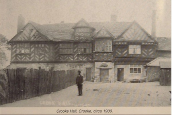
Crooke Hall, built in 1608, no longer stands because of subsidence and was demolished before the second world war. What is to
follow, is peppered with facts and figures, photos of yesteryear scenes as well as some maps of the area at it developed. I
hope you will find it interesting?
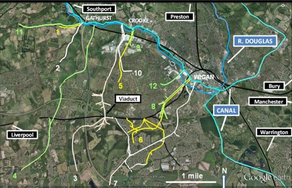
Three miles to the west of Wigan, on the far side of an area known as Standish Lower Ground, but within the parish boundary
of Shevington and situated on the north side of the River Douglas, lies a small hamlet called Crooke Village. The village
was also built on the north side of the Leeds and Liverpool Canal.
It is a quiet little village which has a one road access off the main road next to 'The Owd Barn' Garage, with a total of 65
dwellings, a Public House, a Marina, a Chapel and a Nursery. Thirty five of the properties are owned by Adactus, a housing
authority and the rest are privately owned.
The village, during the summer months can be a hive of activity as people who know the village, come to relax in the
sunshine by the side of the canal and enjoy a pint while watching the canal boats pass by.
Throughout the year, the chapel organises events for its members which are open to anyone who wish to attend and the
pub too have regular events and are ably assisted by the Crooke Village Residents Association. Formed in 2008, it
replaced the former Co-Operative, but this association deals only with the maintenance of pathways, some grass cutting,
tree and shrub pruning, litter picking, some bulb planting with a view of keeping the village looking presentable,
unlike the Co-Operative, which managed the properties and their tenanting. Thanks to the diligence of our active
members over the last couple of years, Crooke has managed to achieve recognition by winning one of the top awards
in the North West in Bloom challenge.
The origin of the village dates back to the 1840s but we need to go back a lot further than that to help us
understand how it all began.
There are several trains of thought as to how Crooke got its name but I would suggest that the name probably came
from the Scandinavians or Vikings as they invaded the east of the country and travelled overland and took control
of parts of south and west Lancashire before the Normans and maybe applied their name for the bend in the river as
Krokr for Crooke, similar to the Norman, French term, Le Croke, as one and the same, meaning a bend in the river
which runs along the south side of the village.
1317/1322.
The first Deeds on record were drawn up in 1317 which was then in the possession of a Robert le Perpounte-Clerk.
Even then, Crooke was a part of Shevington, then spelt Shevyntona.. Another Deed that was then drawn up, said to
be dated 1st February 1322 and is pictured below in which Robert le Perpounte-Clerk renounces any claim he might
have to a certain plot of land in Shevyntona called Le Croke, in favour of Richard, son of Robert de Hultona,
signed by several local land owners as witnesses. That deed is pictures below.
I am very pleased to say that I also have its translation which reads:-
"Know all men by these present that I Robert le Perpounte (etc.) have given granted and for myself and any heirs
released and renounced for ever to Richard son of Robert de Hulton his heirs and assigns all claim to the homage
and services of 12 pence paid yearly as customarily paid to one for a certain place of land called the Crooke so
I that the said Robert nor my heirs or any officer on my name or our names shall leave any claim to the aforesaid
homage and services so that I the said Robert and any heirs may for ever be debarred and excluded from all
occasions at law by any act of mine. Robert le Perpounte warrants the said homage and services for the place
aforesaid with all appurtenances to the aforesaid Richard his heirs and assigns in all things. Witnesses: Richard
de Ince, Thomas de Longetree, Harry de Pembriton, Edmund de Standish, Gilbert de Ines, Hugo the Clerk and others.
Given at Wigan Monday in the Deists of St. Brigit the Virgin [1 February] in the 15th year of the reign of Edward
son of King Edward [1322]".
I am to understand that there are many other sets of deeds but these were the first two. At present I have copies
of just two, the first above and the second dated the 18th of December in the year of 1606, here below:-
I do not have a translation so far, for the picture of the above deed.
1421.
Over time, the land has changed hands many times, but I can tell you that in 1421, the land came into the possession
of the Catterall Family.
1603.
In 1603, Richard Catterall, the then owner of the land in Crooke, died and left instructions with his executors,
that when his son, Peter, then aged 16 years, became of age to marry his future bride, they were to build him a house
and he would then also realise his fathers estate. In 1608, Crooke Hall was built and Peter duly married his bride,
Elizabeth.
CROOKE HALL, the former seat of the Catterall family, stood on low ground on the north bank of the River Douglas
3 miles west of Wigan, what was later to become Crooke Village and at the extreme south-western end of the township.
The canal now passes between where the house used to stand and the River, and the surroundings were desolate and
sordid owing to the working of collieries in the immediate neighbourhood. As the coal industry took off around
1800 so from 1840 onward an ugly colliery village sprang up to the north and west of the Hall.
On this occasion, I will discuss the demise of Crooke Hall at a later time within the Crooke story.
1712.
Coal mining in and around Wigan has been going on since the early 1600s and until the early 1700s, most coal
pits were only a few feet deep because most of the coal mined was close to the surface. Mr. Catterall, who had
a large interest in coal mining, needed to find a better way of moving the product as the road system was far
too cumbersome and ill fitted for moving large quantities of anything. All road transport was by horse and cart
and because the road system was so bad, another way had to be devised and he figured that the best way to move
anything like that, would be by water, but how? He thought about utilising the River Douglas, by making it
navigable, but he discovered it would need an act of parliament to have it canalised, so, as Mr. Catterall was
a Member of Parliament, he applied to Parliament for permission to have the River Douglas widened and deepened
in order to make it navigable to shipping. So, in 1712, a Thomas Steers, a gentleman from Liverpool, surveyed
the River Douglas and recommended that it be made accessible to shipping, enabling the transport of coal from
the coalfields and other products around Wigan down to the Ribble, and onwards to Preston. The canalisation of
the river from its junction with the River Ribble to the Miry Lane End in Wigan was authorised by Parliament
in 1720, with Thomas Steers and William Squire, Esq. of Liverpool as the two proprietors. It took 22 years to
complete and was eventually opened in 1742.
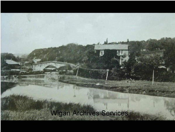
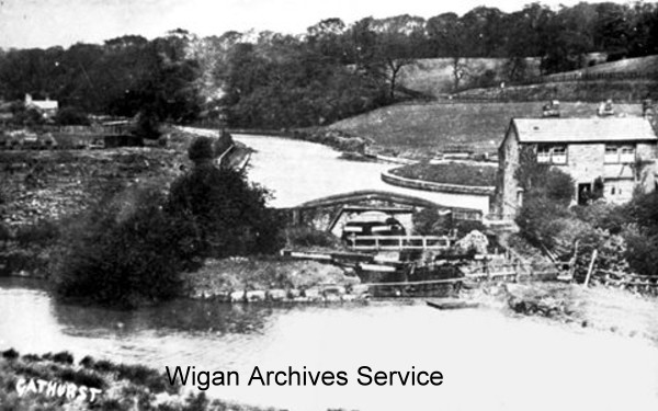
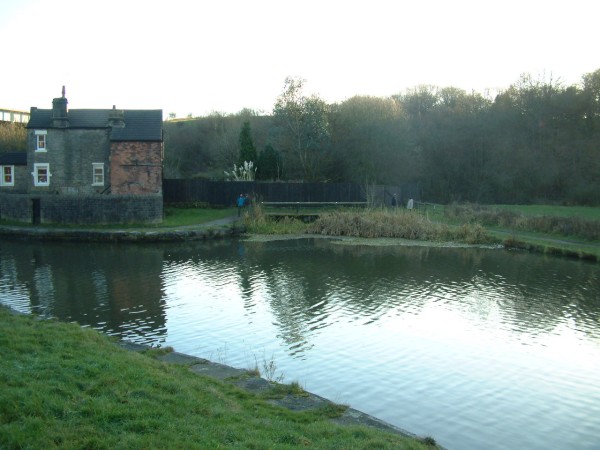
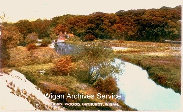
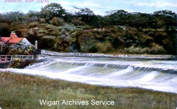
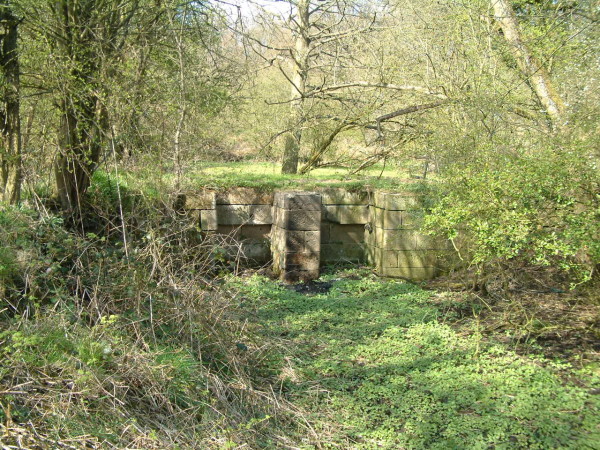
Eventually, in 1780, the canal was extended into Wigan from Dean Lock at Gathurst and the Douglas Navigation was then
bought out by the canal company and all traffic was then transferred onto the canal.
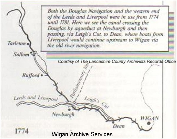
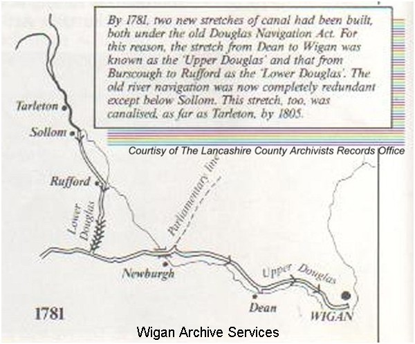
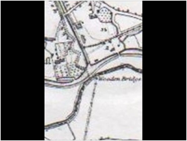
Thus, in 1781, the Douglas Navigation then became redundant and abandoned completely in 1801. As you can see
from the pictures below that the Douglas Navigation was connected to the canal via a lock at Dean Lock at
Gathurst where traffic left the Douglas Navigation to join the Leeds / Liverpool canal. The next pictures
shows how the two systems, The Douglas Navigation and the Leeds to Liverpool canal worked together at Dean
Lock at Gathurst.
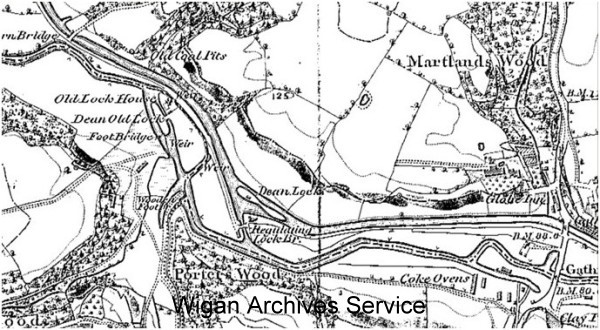
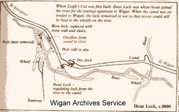
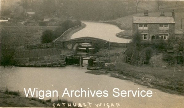
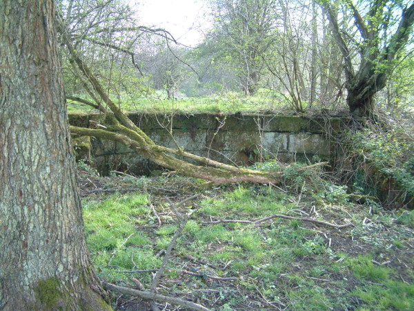
Thanks to a friend, I can now add a couple more pictures of the same area. You will also notice that there
is a house beyond Dean Lock which is no longer there but is mentioned on the first of the two maps above.
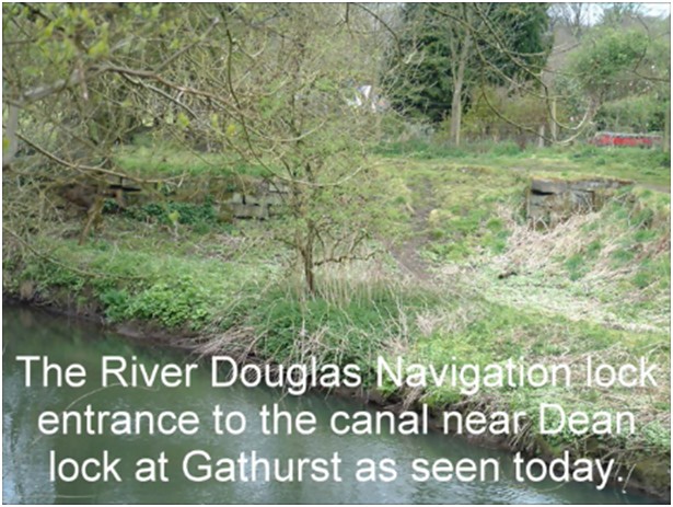
I took a walk down there to see what I could see to find the remains of the replacement stone wall with
sluice where the lock once was as well as one brick weir that is still visible. I hope these are of interest
to you.
Soon after the canal was extended into Wigan, coal was brought down to the canal so that it could be
transported to wherever it was needed, Preston, Liverpool, Wigan and beyond and suddenly, Crooke began
to become a very busy place.
Until the 18th Century, coal was obtained on a small scale, with relatively little effort, from a large
number of places where coal outcropped at or near the surface. From the late 1700's to the early 1900's
the incredible rate at which the coalfield developed was due primarily to two major factors: increasing
demand for coal; and technological advances that enabled vast quantities of coal to be mined and
transported. The spurt in coal mining in the 1770s and the start of the Industrial Revolution was associated
with mining the Orrell 5ft and Orrell 4ft coal seams in Orrell. These coals were high quality, but not
cannel coal. Some of the coal mined around Wigan was Cannel Coal, a much better quality of coal that burned
hotter, better and left less ash. Thanks to the building of the Leeds/Liverpool canal, the coal industry
really took off as there had not been any suitable movement mechanism in place until then. The canal
network had the movement monopoly of coal for the first 50 years of its existence before the railways
started to take business from the canals. In many places, the rail and canal systems worked
side by side for the next 50 years until the combustion engine came into being, but that again, is a
different story. In 1800 there were only 11,000 people living in Wigan. In only thirty years this had
doubled. By the end of the century the working population had risen to 60,000.
One of the main reasons why coal became a more widely used commodity is because Parliament, in their
wisdom, sometime in the 16th century, restricted the use of timber for fuel purposes, thus compelling
householders to find an alternate fuel, so they turned to coal.
1713.
In 1713, the ownership of Crooke Hall changed hands and became the property of an Edward Holt. Over
the next few years, it changed hands a few more times. In 1724 Mr. Holts sister, Elizabeth Morris
took residence followed by her daughter Anne Pearson and then by a second daughter Anne Livesey and
yet again in 1789 by Roscoe, Clarke and German (Colliery Proprietors).
1780.
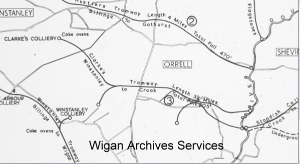
In this year, William Berry who then owned the Orrell Collieries, applied for permission to build
a wooden wagon road from his Post House Estate in Orrell down to the canal at Crooke. So Berry's was the
first mining business to deliver coal to the Douglas Navigation at Crooke. Clarke Collieries bought out
Berry's mines in 1789 or there abouts and extended the wagon way into Winstanley and Longshaw in about 1792 and built
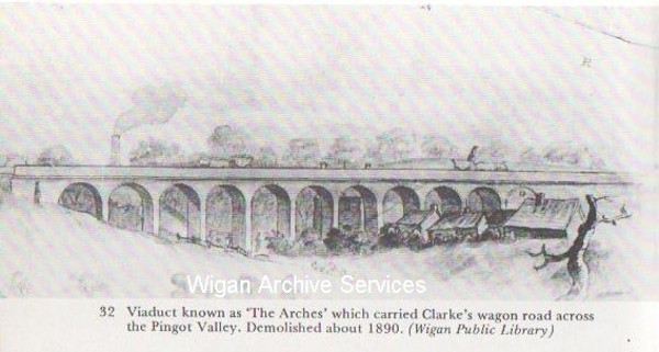
the Arches Viaduct at Pingot or over Smithy Brook.
This sequence of developments was evident on the Ayrfield, Blundells, Hustlers and Berrys railways in Orrell
meaning that there were several wagon/rail roads running to different locations at about the same time,
but in 1792 John Clarke and his partners leased land from Squire William Bankes and started to mine coal in
Winstanley, to the south of Smithy Brook. The only pathway to transport coal from Winstanley down to the canal
at Crooke was to cross Smithy Brook and go uphill to Oldhams Fold on Orrell Road, before descending through
Kitt Green to Crooke. Clarke built a stone viaduct across Smithy Brook, known as The Arches, and built a
gravity- and horse-powered waggonway from Winstanley to connect with Berrys waggonway to the north of Oldhams
Fold, which he had already purchased. The challenge was that about 14 horses had to pull loaded wagons of coal
from The Arches up to Oldhams Fold, a distance of about 600 yards. Due to the Napoleanic Wars, the cost of horses
and horse feed was very high.
The Orrell Collieries had been in business alongside the Pemberton Collieries but not working together for some time.
Coal mining in Winstanley began as far back as 1507 and by the 1790's they produced around 250,000 tons a year,
obtained from all the Orrell coalfields; of this, about 55,000 tons came from Blundell's Orrell Collieries. Annual
output from Winstanley Collieries was perhaps about 5,000 tons at this time. It is thought that, much later,
the Norley pits may have used the same Wgaon Road from the Clarkes pits as they became exhausted of coal? There
were two Wagon Roads built and both berthing on the south side of the canal at Crooke to offload their coal into
barges. When the Douglas Navigation was bought out, the Wagon Roads had to be extended to pass over the Navigation
so as to reach the canal. The bridges were built on the proviso that the structure was well supported, strong and
that in the execution of such work, it did not stop the Douglas Navigation working above seven days. One berthed
opposite the location of the entrance to the Tunnel Canal where the marina is now and the other opposite the future
location of Woodcock Row, a row of 26 terraced houses built to accommodate the influx of miners into the yet to be
built village.
1800.
In 1800, there were only 11,000 people living in Wigan and only 30 years later, the population had doubled. 1n 1888,
Wigan became a County Borough and Pemberton was added but not until 1904. By the turn of the 20th century, the
population of the County Borough of Wigan had increased to over 80,000.
1803.
In 1803, a group of Yorkshire Quakers who as businessmen, invested under the name of Peckover &
Co., were leasing all the coal in the Standish coalfields from the Standish family. In this year,
they sank the first of a few pits and the name Billy (the name of the pit) is thought that the
name may have come from that of a major partner in the Peckover Co. who had recently died -
William Hustler, or another possibility is that it was named after William Ellam, the agent and
manager? From this pit, a tramway was built that took coal in trucks down an incline to the
canal at Crooke and they built a tipper wharf in what became the Tunnel Canal entrance where the
entrance to the marina is now, where coal was tipped into waiting barges. There were
three other pits all in the same area and all four pits brought coal down the tramway.
They were Yorkshire Pit, Wood Pit and 'Park Pit' and of these; Billy Pit was the
deepest measuring 155 yards.
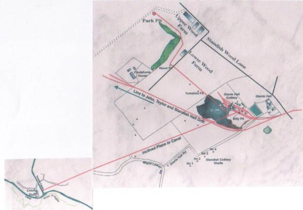
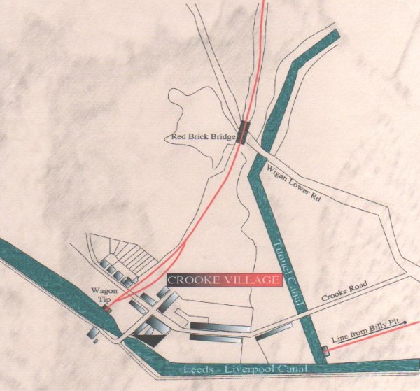
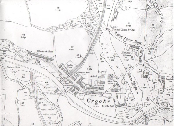
The map below shows where Billy pit was along with the others as well as Giants Hall colliery
which later replaced Billy and the other associated pits. It also shows where in Crooke the
inclined wagon road delivered to.
Billy pit was worked out first and closed in 1840 but the others kept going and used the same
tramway until they too ran out of coal. Yorkshire Pit closed in 1844, followed by Wood Pit, that
closed in 1848 and finally Park Pit closed in 1850. Soon after, the tramway was raised.
1804.
In 1804, Robert Daglish of Northumberland, an accomplished mechanical engineer, took over
the management of Haigh Ironworks belonging to the Earl of Balcarres. During his time there,
he designed a number of steam engines for pumping and winding work in local collieries, all
of which were hailed as a radical improvement on existing designs, and led to greater safety
and efficiency.
In 1810, he left Haigh Ironworks to work for coal owner John Clarke as manager of the Orrell and
Winstanley collieries on the other side of Wigan. Here, the horse tramway built in wood was being used
to haul coal three or so miles from the collieries to the Leeds/Liverpool canal quays
at Crooke. These quays or tippers were located on the maps below. The first map shows the
tramways to the nearest mine, along its line of route, it is thought that, much later, the
Norley pits probably used the lower section of Clarke's railway as Clarke's pit became exhausted
in Winstanley

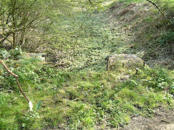
The picture above shows a drop in the towpath, where, just before the drop was where the
most easterly of the Yorkshire Horse tippers used to be. The picture was taken sometime
around 1964. The next map and picture shows the tipping point furthest east in Crooke,
that being opposite the Marina.
Also on the map above can be seen the tramway from Billy Pit.
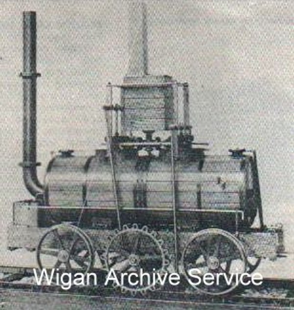
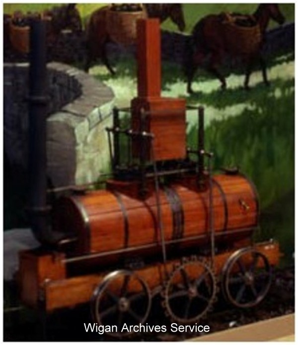
Soon after taking office as manager, Robert Daglish commissioned Haigh Foundry to build a
steam locomotive with a view of replacing the horse tramway down to the canal. He studied
the first steam locomotive at Middleton Colliery in Leeds, adopted John Blenkinsiop's rack
and pinion traction system, and designed a much improved steam engine and railway track.
The fish-bellied rails were sturdy and on the left side fitted to engage Blenkisop's rack
and pinion system. The rails were set into thick stone sleepers. The picture below show
the old sleepers still in place in Winstanley.

This enabled the hauling of heavy loads by a relatively light engine. So by 1813, this Engine
came into service making this certainly the first steam locomotive to be built that operated
in Lancashire. Also, as there are suggestions that people were carried on the railway, albeit
unofficially, it has claims to being one of the first passenger carrying trains in the world."
[Trevithick transported passengers on his demonstration steam railways in 1804-8, but they did
not last long and were not commercially successful, and Middleton railway may have carried
passengers before the Walking Horse.] A few years later two additional locomotives were
commissioned and put into operation at the Colliery. It had the capacity to haul 30 tons up
a one in thirty six gradient, or a load of ninety tons on the level, at a speed of between
three and five miles per hour. Christened 'The Yorkshire Horse' but also known locally as
'The Walking Horse', Daglish's locomotive successfully replaced the use of horses on the tramway
whilst George Stephenson was still developing Blucher, a steam railway engine at Killingworth
colliery. These engines must have provided a spectacular sight for the inhabitants of the Orrell
area. Previously fourteen draught horses were needed to perform similar work and it was estimated
they cost the considerable sum of five hundred pounds per annum on stabling and fodder, all
because of the Napoleanic Wars. This locomotive also was the first to run over a viaduct, the
first to run for four decades, the first to haul a load up a four percent incline, also the first
commercially successful steam locomotive in the world to have a wrought-iron boiler and chimney
and feed pump, the third commercially successful steam locomotive in the world and compared to the
first two Middleton Colliery locomotives, the Walking Horse was one to two tons heavier, had more
horsepower (8 hp) and the tracks had stronger rails (4 ft, fish belly), pedestals and sleepers with
chairs fixed by through bolts.
I have found an early map of some of the tramway network and have isolated the area concerned
for this story, running from Winstanley, through Orrell and on down to the canal at Crooke.
Clarkes Wagon Road as it was called, ran for 36 years, closing in 1849, before the engines
were decommissioned.
One of the Walking Horses, or at least its engine part, spent its latter years in the
colliery stables cutting hay and mixing provender. It was finally demolished in the early 1920s.
In 1818, Robert Daglish became a partner in the St. Helens Foundry and Brock Mill Forge,
where he built the Arley Engine and many others which traded as Robert Daglish & Co. In
the years that followed, Daglish's reputation as an engineer led to him being appointed
consultant engineer on many railway projects, both in England and on the American continent.
In 1825, for instance, he commenced the surveying and engineering of the Bolton and Leigh
Railway, Lancashire's first public railway. Among the many projects he undertook, one was
to supply the pistons for Stephensons Rocket, which came into service the following year,
in 1826, some 16 years after Robert had become manager of Clark collieries.
Robert Daglish had Orrell Lodge built for himself which is now the Wish FM Radio Station
on Orrell Road. He lived to the ripe old age of 88, passing away in 1865 and his wife died in
her 70th year in 1849 and they are buried together in the church yard of St. Thomas the
Martyr in Upholland side by side. His inscription reads In this vault lie the remains
of Robert Daglish Esq, of Orrell Lodge who died December 26th 1865, Aged 88 years".
In 1938 Eli Bankes of Pemberton made an excellent working model of an early steam locomotive
that he called "The Yorkshire Horse". This was actually a model of the first commercially
successful steam locomotive in the world built in Leeds and first operated on the Middleton
Railway in June 1812. Daglish's steam locomotive, "The Walking Horse" was similar to the
Yorkshire locomotive, but much improved when it started work in Winstanley and Orrell in
January 1813. Eli gave the model, mounted in a glass case to the Miners Home in Blackpool.
Aroung 10 years ago, the model went missing and since then, the building has been converted
into luxury apartments. I am to understand that for the last two years, the model is now at
the Beamish Museum, in county Durham.
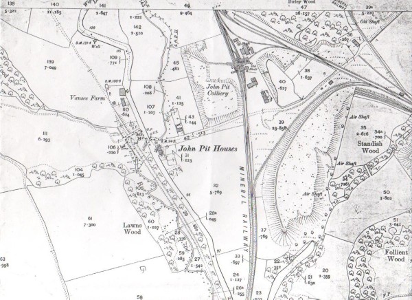
1806.
In 1806, the Yorkshire Quakers or the Peckover & Co., were also responsible for the construction of
the Tunnel Canal. Owned by the Standish Coal Company but rented by Peckover & Co., it was situated
some 2000 yards north of Crooke. A canal was dug and ran the course of Mill Brook and then turned
right passing under Wigan Lower Road and through what is now the property of De Roma Ice Cream,
travelling a couple more hundreds of yards before it entered a brick built tunnel. The pit itself
was otherwise accessed by two vertical shafts, one for the miners and the other for ventilation.
The brick tunnel was built to allow barges to travel to a pit head wharf underground. It extended
600 yards underground where it intercepted with the Ince 7ft coal seam and then continued for a
further 500 yards to an underground wharf. The estimated area for the underground wharf is under
Birley Wood house which would later become John Pit Lodge. The tunnel was built of brick and as
there was no towpath, the barges had to be walked in and out by the bargees along the walls and
roof of the tunnel. The picture below is not the Crooke tunnel but one like it to show what it may
have looked like.
The barges were loaded by the miners by dragging baskets of coal from the pit face to the underground
wharf. This wharf was only 96ft below the surface and the two shafts that were sunk went only to that
depth and provided ventilation and also a means of entering and exiting the mine for the workers. It is
thought that this was done by means of ladders, the miners having to carry their picks and other tools
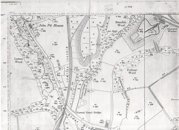
attached to loops on the back of their waistcoats. Several years after the tunnel canal fell into disuse,
Taylor Pit was sunk alongside it in 1864 and miners descending into the pit, right up to the 1950s, said that the
roof of the tunnel could still be seen. It is not known exactly when the Tunnel Canal was abandoned but
it was probably before 1849 when the mine shafts were sunk much deeper. Unfortunately, it was not very
successful as it only produced something over 200,000 tons and was therefore abandoned and the pit was
originally thought to have closed around 1849. We know it was still working in 1835 because the tunnel
entrance was widened. It latterly served as a drain for the underground workings as it still does today,
even though the Tunnel Canal entrance can no longer be seen. There were also four ventilation shafts
along its line of route which are no longer visible. Records show that there were two fatalities in the
Tunnel Colliery'. The first, on the 25th of May in 1863, was a Thomas Aspinall who was a Sinker who
interfered with a miss-fired shot and the second, on the 7th of May in 1867, a Joseph Turner a
Hooker-on, aged 18, was drowned in a sump. It was previously thought the pit closed a lot earlier,
around 1850 but 1880 is a more probable year. I am to understand that the shafts for the Tunnel canal
were used by the miners of Taylor Pit until it closed.
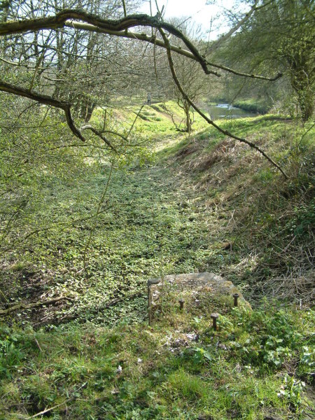
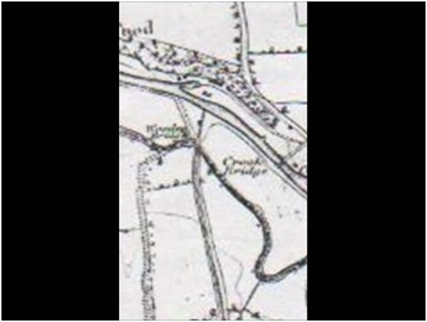
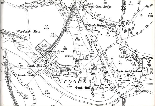
The above map, dated somewhere around 1840, shows the route of the 'Tunnel Canal' as well as the tramway from
another pit I will be discussing shortly. The map below, shows the Air Shafts for the Tunnel Canal and
is dated sometime around 1870.
1816.
John Clarke, Proprietor of Clarke's Winstanley and Orrell Collieries, became bankrupt in 1816 and was forced to
sell his home in Orrell Mount. He lived the last five years of his life in Crooke Hall, of which he then had sole
ownership But in 1821, he died and was buried at St. Thomas the Martyr in Upholland. So in 1821, it all changed
again and Crooke Hall became the property of a Joshua Lace from Liverpool. By about 1850, it then became the
property of The Woodcock and Eckersley families. The Eckersleys owned Trencherfield Mill off Wallgate in Wigan,
later to be opening in 1901 and Mr. Woodcock owned land in Crooke and later houses he had built, looking forward
to the development of the village, he then owns the land next to the Crooke Hall Inn property. See further below.
1836.
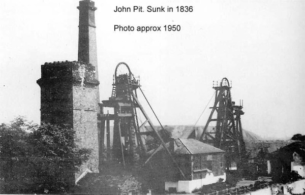
In 1836, John Pit, owned by Standish and Shevington Cannel Company, opened but because the coal that
was being mined was of poor quality, the pit soon closed and was abandoned, for then, to be re-opened in 1858.
1841.
The United Kingdom census began in 1801 but those following up until 1831, did not record everything reliably as
it is done today. As it happens, in 1841, the regular details that can be seen on todays census was the first
census to contain all that detail so the population of Crooke as of the 6th of June, numbered 66.
1844.
In this year of 1844, John Taylor, originally a Liverpool coal merchant took over most of the leases for the Standish
mines and in 1848, moved to Wigan and then moved into Standish Hall. Five years later, in 1853, he allowed
his son, John Taylor Jnr, along with two partners, to work part of the coalfield. It was these three who re-opened
John Pit in 1858. , John Taylor Jnr. ran the pit for 13 years, from 1853 to 1866 when the Wigan Coal & Iron Co. then
took over the Standish mining leasings. We have not yet finished with John Taylor so I will return to him later.
1845.
In 1845, although the map of the time shows Crooke as an area rather than a village, it was in this year that the
village began to grow. Buildings seem to have shot up over night and like magic, a village was born. It is quite
likely that the village began to develop a few of years earlier, maybe in 1840, as it takes time for plans to be
accepted let alone buildings to be built. The first public building that was built in that year was a Church of
England Mission school. The village sprang up very quickly as did the peoples needs, hence, the school.
1850.
Sometime in the early 1850s, Crooke Hall became the property of the Woodcock and Eckersley families.
Mr Woodcock had some mining interests and the Eckersley family owned the Trencherfield Mill which was
later built in 1901.
1851.
In the year of 1851, the population in Crooke had decreased to 47. The reasons for that are unknown
but it was soon to increase further rapidly.
The Landlord of The Crooke Hall was Mr. James Bell.
It would seem that a number of houses had been built by the time the Crooke Hall Inn deeds were printed as
shown by this next entry. Alas there is no date upon it but I reckon it was probably drawn up around 1855?
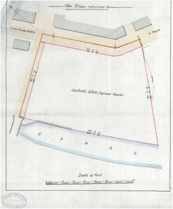
A second plan was to follow showing the Inn built along with its adjoining out buildings one of which
would have been a stable.
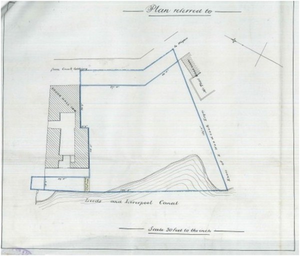
By way of interest, each plan also suggests a Crooke Hall Colliery existed as it is mentioned and
indicated to be on the left hand side of the plan. This plan also shows that some of the land
was owned by Mr. Woodcock to the right as well as a Mr Thomas Woosnam so the second plan would
date around 1870.
1856.
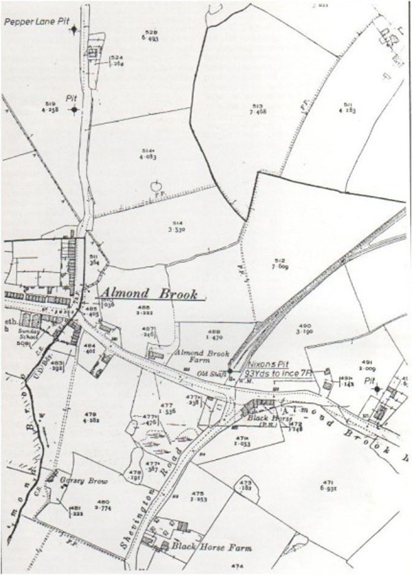
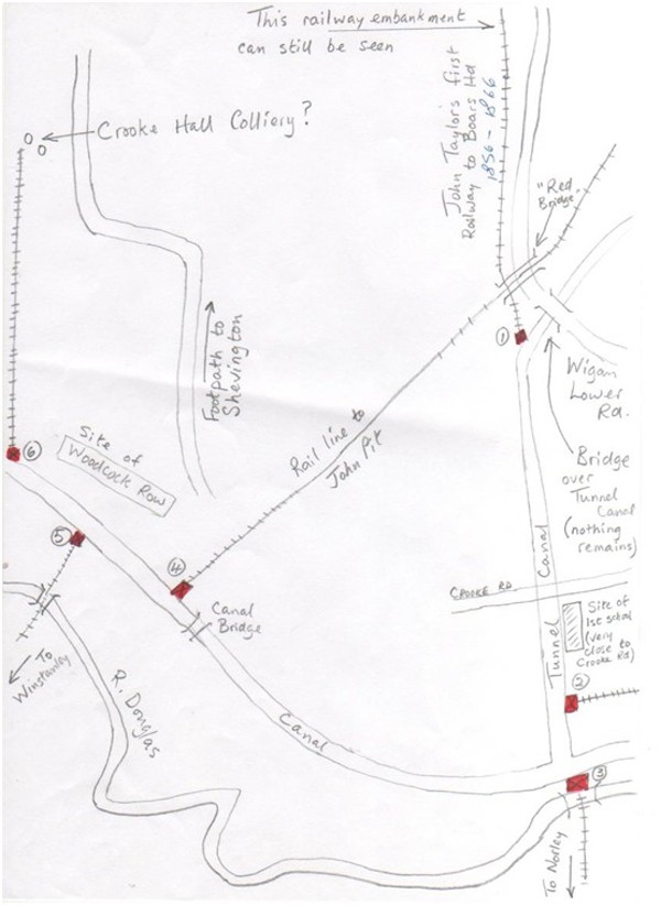
In 1856, John Taylor Snr, was running Nixon Pit, next door to where Robin Hill Drift mine was soon to be
and where The Almond Brook Hotel is today. In or about this year, he had a tramway built to carry coal from
Nixon Pit, via Arbour Pit off Arbour Lane on down to Crooke.
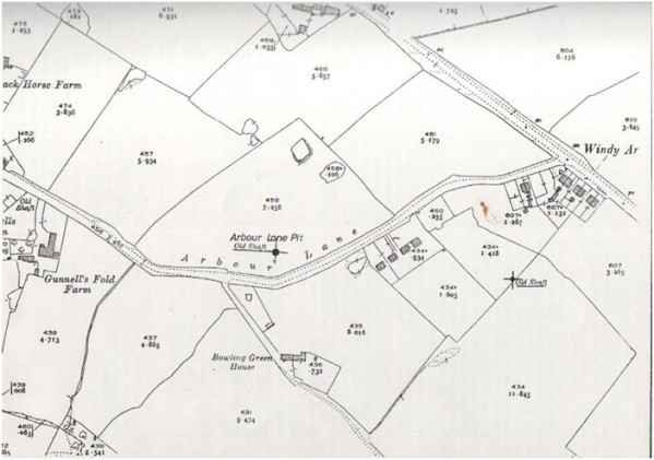
The tramway left Arbour Pit and passed through what is now Shevington High School grounds, across Chapel
lane by Club House Farm and into the fields passing to the rear of Vause Farm and then running parallel
to Wigan Lower Road passing John Pit entrance, through Lawns wood on a descending embankment, the remains
of which can still be seen today, until it reached the Tunnel Canal, where the coal was tipped into waiting
barges. There was a rail line that ran the other way to the Boars Head but this way, coal could be delivered
to the canal and be distributed just as fast.
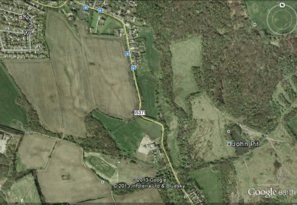
This next picture was captured on Google Earth and the course of the old tramway across the fields behind
and through Vause Farm can be clearly seen and when you pass through Lawns Wood near to where John Pit
used to be, you will also notice that you have to climb over an embankment where the old tramway used to be,
before you can leave Lawns Wood.
The next two pictures are maps drawn up in 1892 and show the course of the tramway through Lawns Wood. It
proceeded to a point where the canal turned to go down to the canal after crossing under Wigan Lower Road.
This tramway ran for ten years or so and only ceased when either coal reserves from Nixon and Arbour pits ran
out or, as it happened, coincided with the building of a rail line from John Pit into Crooke, crossing over a
purpose built bridge over Wigan Lower Road, named as 'Red Bridge'. The Tunnel Canal may have officially
closed even though its workings and canal were still there but when the bridge was built, this tramway ceased
to function.
Also in this year of 1856, a new pit just outside Crooke was opened. It was named Crooke Hall Colliery and references
to it have already been mentioned in the Crooke Hall Inn plans shown above. At present, I have very little
information about its ownership but this is what I do know.
Crooke Hall Colliery or Collieries as there were two pits close to one another, probably came into existence around
1855 and were reported to have been worked for about 10 years. By all accounts, they were reasonably productive pits
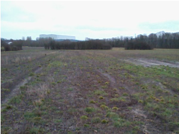
as they produced something like 10,000 tons of coal a year. They were situated in the fields behind Crooke, to the west
of the Crooke to Shevington cart track across the fields. They had their own tramway which took coal in trucks down to the
canal passing to the right of where Woodcock Row was yet to be built. Although there are no remains to be seen,
there are two depressions in the ground in the field where the pits were reported to have been, which can be seen as the
following pictures shows. All around these depressions there are shards of coal littering the ground in that area
rather than anywhere else.
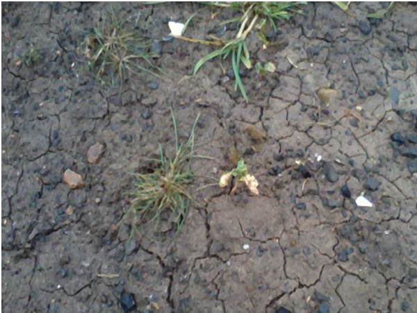
These are the shards of coal that litter the field in that area.
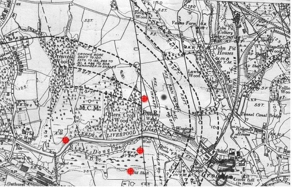
Someone kindly forwarded to me an ordinance map showing four old mine working sites without the site of Crooke
Hall Colliery and looking at the ground, have estimated its position to be where the black dot is to the right
of the four red dots. I estimate this map to date around 1880/85 on the condition of the ground near to the
Crooke Hall.
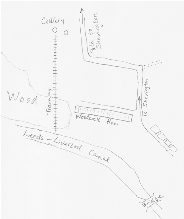
Another contact has drawn me a map of where it was likely to have be situated showing the probable route of
the tramway as previously mentioned.
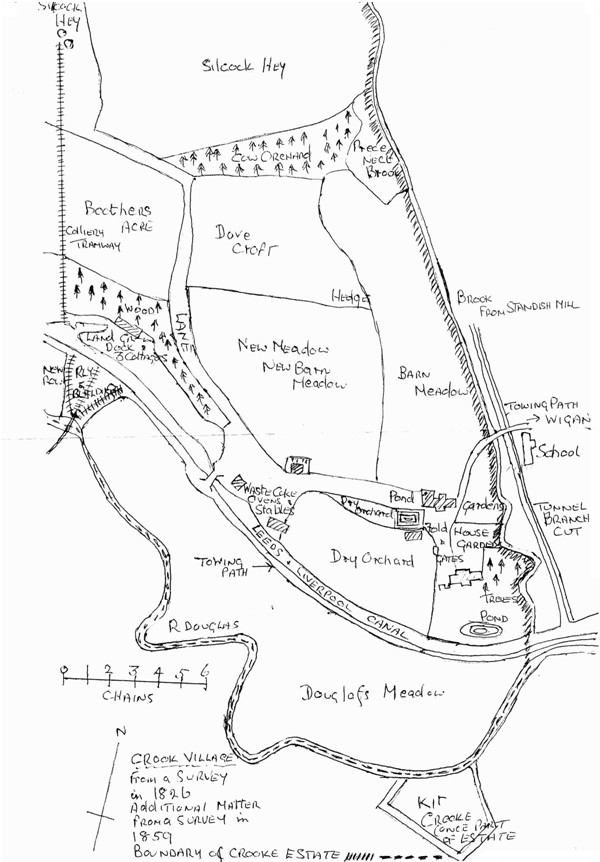
In the Autumn of 2013, Clogs & Gansey, a publication akin to the canals, published an article about Crooke which
furnished me with what I was looking for. I was in search for the evidence and markings of the individual areas
within the Crooke Hall estate as the already above mentioned mines/s are indicated within the area of Silcock Hey.
This map indicates where that area was and also shows where the coal pit tramway was, a reflection of the previous
map. So, below, is a copy of that map although it is not totally clear as to when it was drawn up but is thought
to be dated around 1859 although the original survey was probably carried out around 1826 with the additional
material added. The Canal and River Trust were not able to help me in this matter but thanks to Mike Clarke, we
now have a copy of this map.
Also in this year of 1856, The then owner of Crooke Hall, Mr. Woodcock, proceeded to have built a row of terraced
houses which were to become Woodcock Row. There were twenty six houses built in all over a two year
period. Inserted into the wall were two date blocks, the first over doors 6/7 was dated 1856 and the second
around No.16, was the date of 1858. Mr. Woodcock owned quite a lot of land as you can be seen by his name
being mentioned on the Crooke Hall Inn plans where there is either land or houses built with his name. I
originally thought that Woodcock Row was one of the first blocks of houses to be built in Crooke but I
now know that the Church of England Mission Hall and School was the first official building built in 1845 but what I
can say is that, to my knowledge, Woodcock Row was the first block of houses dated with date blocks in the walls. I
don't think it was the last house built because house No. 113 has a date stone dated 1893 so maybe that was the
last? I am not 100% sure but I am to believe that Mr. Woodcock may have also been part of a family of Wigan
Solicitor but I will try to research that to see if I can confirm it.
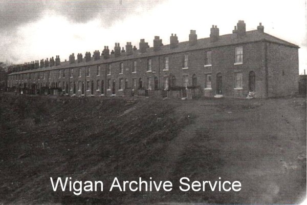
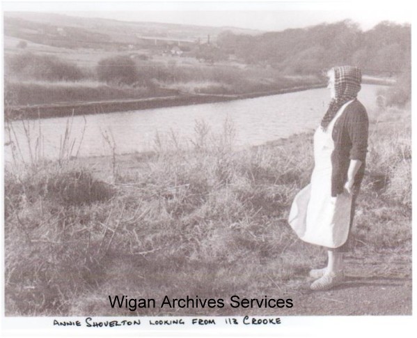
This next picture shows the village or especially Woodcock Row from the path that leeds to Shevington across
the fields. It was not the best of days as far as the weather was concerned but shows the row above anything
else, the picture was taken in 1961.

1856.
John Pit is re-opening under the management of John Taylor Jnr and his two associates. Just to remind
you that they started working on the pit in 1853.
1861.
This next date of 1861, shows an increase in the village population. By this date, it had risen to 352.
1862.
In 1862 the Wigan Miners Association was formed as the Wigan Miners Provident Benefit Society, taking the
above title in 1881. It was one of the strongest of the organised districts in Lancashire in the 1860's
which joined the National Association of Coal, Line and Ironstone Workers in 1863 and the Amalgamated
Association of Miners in 1869 with William Pickard as Agent. Pickard was also treasurer of the Miners
National Association, thus keeping a foot in both camps. In 1874 Skelmersdale and Tyldesley broke away
to form separate organisations. They were followed in 1877 by Aspull, Blackrod, Hindley, Leigh and Bedford,
Platt Bridge and Standish and Pemberton all of which later joined the Lancashire and Cheshire Miners
Federation. The association registered in 1891, meeting at the Miners Hall, 33 Millgate, Wigan and was
dessolved in 1908.
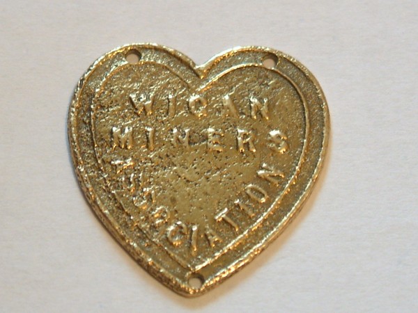
I can see you now asking, what has all this to do with Crooke? The answer is that very recently, a resident
of the village, found in their garden, a gold coloured badge. Upon it is written, 'Wigan Miners Association'.
This is a badge that a union representative would have worn on their shirt or jacket so that union or none
union members could see who their representative was. There was, however, a problem. Unions, in those days,
were not welcome and if your employer found you to be a unionist, you would very likely lose your job
because employers did not want people causing unrest in the labour camp demanding better conditions or extra
pay. The mining bosses had the miners where they wanted them. So, this badge, belonged to a union rep who,
it is thought, lived in Crooke. This person could have lived in Crooke anywhere between 1862 up to 1908, so
it is a stab in the dark as to when it was dropped or buried.
Also in this year, according to the deeds dated 17th Feb 1862, the Crooke Hall Inn, was bought by a Thomas Morris
for £346.16.8. It is not altogether clear if the pub had been built at this time but a subsequent deed of October 1867,
indicates that the pub by then had been built. The land had been in the ownership of John and Henry Woodcock
preceeding the sale to Thomas Morris.
In December of this year, a James Gore, a miner of 64 years of age became headline news when he was killed in a freak accident
at John Pit. According to my calculations, James being born in 1818, and his death happening in 1862, makes him aged 44 years. This is what
the papers had to say:-
Killed age 46 when a tub fell on him. (D cert obtained; inquest held on 22 Dec 1962; no records kept.) Bur at St Ann`s, Shevington;
grave not found (as of 23 April 2005). Newspaper report of death reads: From the "Wigan Observer" Friday, December 26, 1862, Page 4, Column a.
FATAL COLLIERY ACCIDENT. -- The gale which raged so furiously in this neighbourhood on Thursday night and the whole of yesterday, was productive
of a fatal accident at the Standish and Shevington Coal and Cannel Company`s "John Pit," near Wigan. Between five and six o`clock yesterday
morning six men employed at the colliery entered the cage at the bottom of the shaft in order to ascend. Before the signal had been given the
noise of something falling was heard, and five of the men hurriedly left the cage. The sixth, James Gore, an old man, between 50 and 60, was
unable to follow the others before a tub of cannel, which had been blown into the shaft from the pit brow by the force of the gale, fell upon the
cage, completely smashing it and inflicting such injuries upon Gore as caused his immediate death. Deceased resided at Crook, near Wigan, and he
leaves a wife and five children. (MS)
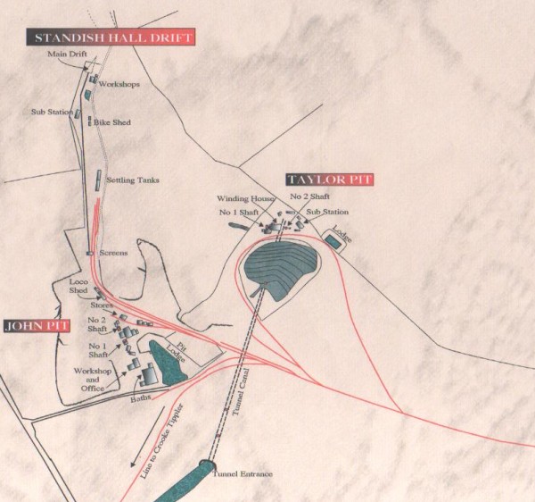
1864.
This was the year that Taylor pit was sunk. It was situated where the tunnel canal treminated where
the underground wharfs were. The former shaft used for the Tunnel canal were also used by Taylor pit miners.
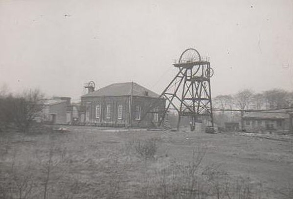
The following map shows where Taylor pit was in relation to the Tunnel Canal/pit along with John pit that was soon to be
opened along with Shevington Hall Drift mine that was not to opened until 1949.
1865.
In 1865, a man named Thomas Woosnam, who formerly worked in The Clarence Hotel in Wigan, married and moved
into Crooke. He immediately started a Grocery, Bakers and General Supplies business, obtaining his stock by
barge from Liverpool and he became very successful. As a result of his business success, he could afford to have 20 houses
built in the village and one of those was converted into a meeting room for the Wesleyan Methodists.
I think now is the right time to start the Wesleyan or Methodist story.
There were two Brothers of the Wesleyan faith namely Brother P. Wright and Brother H Farrimond who moved into
Crooke and took up residence in Woodcock Row soon after it was completed and immediately set up a meeting
room in their house to hold faith meetings. Soon after Thomas Woosnam had had his 20 houses built, they moved into
one of his houses and they opened up the upper floor to accommodate the growing numbers of the worshippers.
There were 2 Methodist groups and 9 societies in the circuit around Wigan and out as far as Newburgh, totalling
a gross membership of 237, but the members of Crooke were the driving force of the movement. The two groups
eventually amalgamated together to form one movement. The house pictures below was the house that was used
as their meeting house and became known locally as 'The Cathedral'.
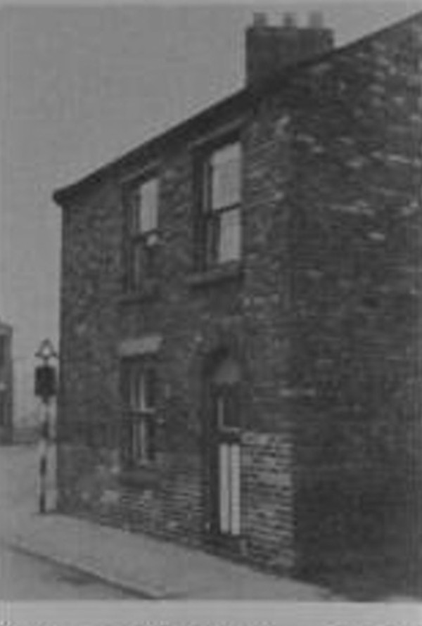
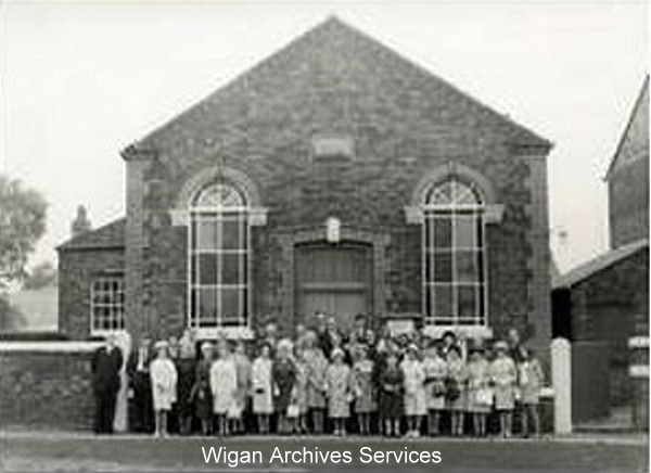
In 1867, they finally got a piece of land and within that year, the chapel was up and open for business,
presided by Rev. J. Prestwich. The picture below was taken in 1967, on the centenary of its conception.
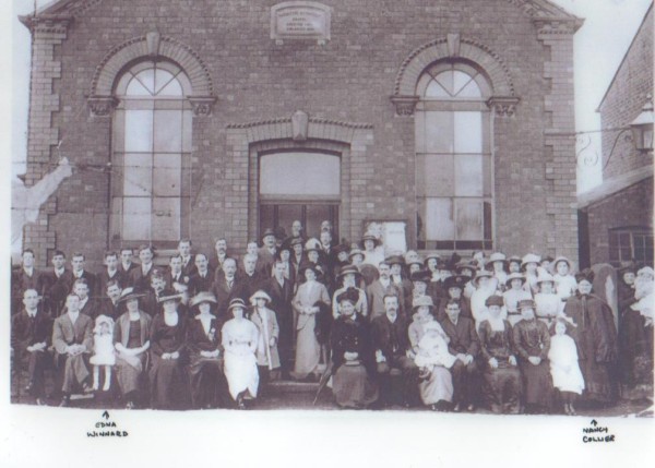
I also have a second picture of a gathering outside the chapel, probably dating back to the twenties of thirties.
I cannot remember where I got the picture from but there are a couple of people identified on the picture.
1866.
It was in this year when John Taylor's loyalty changed from the Standish and Shevington Cannel Company
as they were taken over by The Wigan Coal & Iron Company. They took control of all the mining leases in
the area. All the interested mining companies joined forces to make one business.
This was also the same year that a rail line from John Pit into Crooke was built, for the intention of delivering
coal to the canal and to have it loaded into barges so that it could be transported to Liverpool and beyond.
The rail line passed over Wigan Lower Road to the west of the Tunnel canal and over what was the wagonroad
from Nixon pit, recently closed. The bridge was known locally as 'Red Bridge'.
This next picture shows a plan of the village and where the rail line ran, over Wigan Lower Road and on down to
the canal. It also shows the old route of the Tunnel Canal.
Over the years, the design of the 'Tip' or Tippler as it more affectionately known or even 'The Pier' changed
in its design from time to time but the end result was always the same. I have a few pictures of what it used
to look like so here they are.
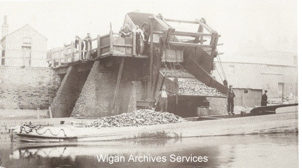
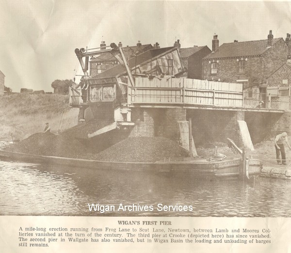
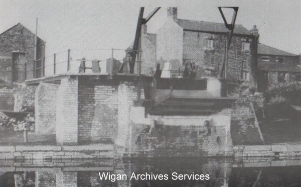
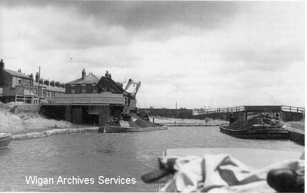
This next picture was taken in 1938 and one of those pictured is still alive to this day.

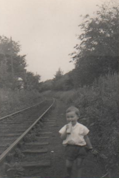
I have only one picture of the rail line in situ and a picture of Peter Anderton, then a child standing beside
it. The family used to be bargees but they moved into a house in the village and they used to live at No. 101.
These days, although it is no longer there, it is referred to as 'The Tippler' but I am reliably informed it
was called 'The Tip', the difference being that a 'Tippler', empties a wagon by rolling it over sideways thus
emptying the load over the side whereas the 'Tip, emptied the wagons by the end or in line of route. I thought
I had better qualify the distinction before I continue?
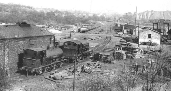
So, in total, there were 6 coal loading points in and around the village. Courtesy of John Rigby, who has helped
me considerably in my fact finding mission, has also supplied me with a small map showing all the loading
locations to help give you an idea as to how close together they all were, also indicating how busy the village
was becoming.
As time went by, the more prosperous the village became and more and more businesses opened up. The population
too was also on the increase so it became a hive of activity.
1868.
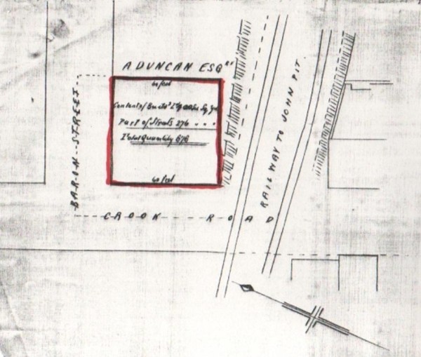
Plans were submitted for the construction of a new public house which was to be called, 'The Duncan Arms'. It
was to be built on the west side of the John Pit rail line to the rear of the tip or pier in Crooke. It stood 100
yards to the west of 'The Crooke Hall Inn' and within its' plans, it shows a potential road development that
never took place. Baron Street as it was named was never built probably because of the close proximity to the
John Pit rail line or perhaps the need for new houses was not as great? The reasons given are speculation and
could be wrong but the planned road is fact because it is there on the plan.
1871.
The population of Crooke had now risen to 571.
It is also listed within the 1871 census that the Landlord and Lady of the Crooke Hall Inn was John and Elizabeth
Tyrer. According to the census, they had no children but they did have a servent named Ellen Whitter who was
then aged 17 years.
The Duncan Arms, the other pub in the village, the Landlord and Lady were Peter Edwards, aged 29 years and his
wife, Elizabeth, aged 28.
Crooke Hall, at this time, was in the ownership of Hugh Middleton who was then 50 years of age and employed 8 farm
hands. He was Scottish and his wife Jane 48, came from Hale, Lancashire.
Although I have shown local maps of coal routes from pits to canal and/or the Douglas Navigation, I do have one map
which gives an overall view of the area along with all the other routes that were in use between 1770 and 1870. I
feel it would be a little remiss of me if I did not include this entry.
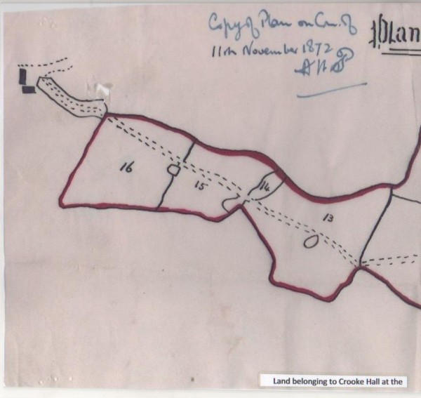
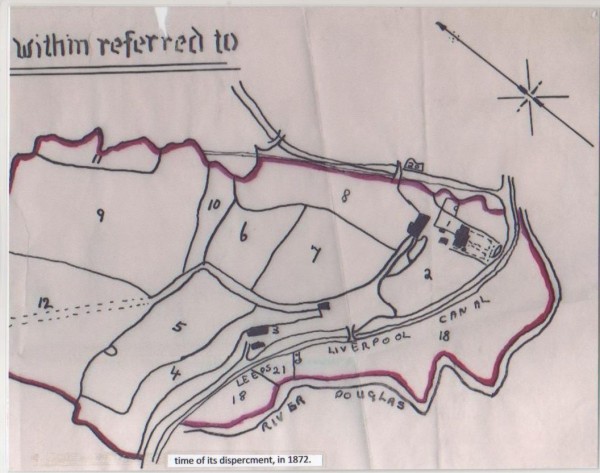
1872.
Thanks to one of my contacts, I received a map of Crooke Hall Estate, which shows all bar a couple of the
estate areas dated in this year. I cannot tell you anything special about it but thought you might like to see
what it looked like?
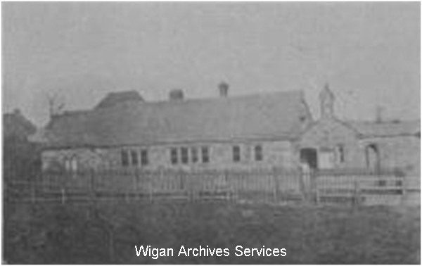
Also in this year, for some time, the Mission School and other buildings in the near vicinity were suffering from the affects
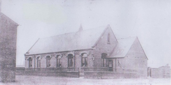
of subsidence as a result of mining. Consequently, the school had began to sink into the ground and because it was
beside the the Tunnel canal, water from the canal was flowing into the building. A new plot of land was selected
and a new school building was built and in 1872, all the classes were transferred into the new school and the old
Mission school was abandoned. A Mr. Isaac Naylor was appointed as Headmaster and by the end of his first two months,
he had 124 pupils with little or no equipment with which to teach them.

I have two maps showing how bad the problem was and how the properties were affected. The first in 1889 and the
second in 1892.
The next picture shows the new school built to replace the Mission School.
1874.
Living conditions in Crooke, by this time, had become filthy and a complaint was registered as you can see from this
following document:-
The living conditions of some Standish miners are exemplified in an article, written in the first person, published
in the Wigan Observer on the 24th of October 1874. It reads:-
"The Village of Crooke Complaint"
"I do not think there is a more dirty and more neglected place in England than I am".
"I am told that in other places the people who live there put a top coat of stones on their streets and so when
they want to walk about, they can do it and have their feet dry, even after a heavy shower. But with me it is different;
People build houses on me and leave so little space between row and row, that air can scarcely get between the rows
and the roads are made of dirt and when people walk about on them, they take a good deal of dirt into the houses when
they go in and no matter how clean the wife is, the house is just as if it had never been cleaned, with the husband and
the children going out and in with dirty clogs, so the insides of the houses, I am told, are always dirty. And I don't
think the houses are ever whitewashed, or not very often, so when sickness comes it lays a terrible hold on the people
and they can scarcely shake it off".
"I heard somebody read a letter out of the paper about the dirty state I am in and the letter said there was scarlet
fever and other zymotic diseases about the place. I cannot tell what zymotic diseases are, but if they have anything
to do with dirt, I can well believe the writer tells the truth. I have not got a decent drain through me and whatever
dirty water or slops are thrown down the sink into me all over and make me quite ill".
"I hear that this authority is going to burn a deal of property and the fever with it and they are going to close the
schools and the children won't have any place to go and they will go into each other's houses and spread zymotic diseases
and there will be more burning property".
"It is a pity to make such a loss to poor people; don't you think it would be better to prevent than cure, as I think
they might have done?
Crooke Village"
1881.
By 1881, the population in the village had decreased to 489, reasons unknown.
Also in this year, the Landlord and Lady of The Crooke Hall Inn was John and Mary Barton aged 40 and 30 years respectively along
with their three children, Elizabeth 5, Jane 4 and Thomas 1.
The Landlord and Lady of the Duncan Arms was Abraham and Margaret Cartmel, aged 33 and 34 years respectively. Their
children were, John Thomas 12, Levi 7 and Albert 2. It is possible the Cartmel family went on to run a general
store in the village a while later or at the same time? I do not know if they were family connected but there was a general
store run by a family of that name?
1887.
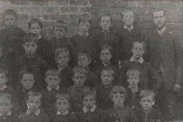
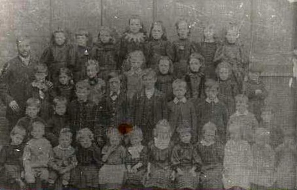
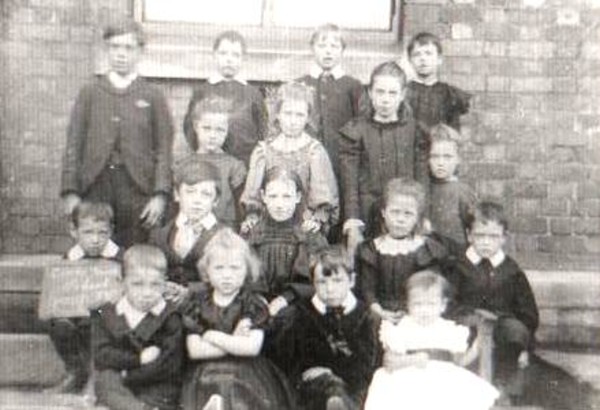
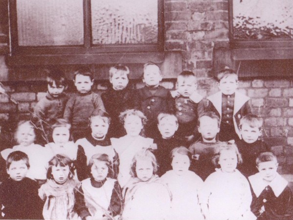
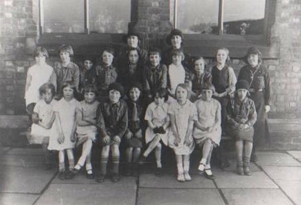
The first class picture of the Crooke school children that I have a copy of, was taken in 1887. See below.
1889.
It was in this year that the Duncan Arms submitted plans for a Bowling Green. The Crooke Hall Inn had
one as well as this map below shows.

1890.
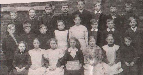
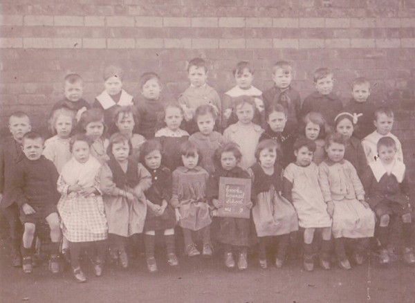
Here's the next school picture taken in 1890.
1891.
The population of the village hadnow risen up to 551.
The Landlord and Lady of The Crooke Hall Inn was still in the hands of the Barton Family whereas the Landlord and
Lady of the Duncan Arms was Richard Fairhurst and his wife Ellen aged 35 and 33 years respectively. They had five
children, Henry, aged 15 who worked as a railway clerk in a goods depot, Joeseph, aged 11 years, who was at school,
Annie, aged 6, James, aged 4 and Richard aged 3. They also had a domestic servant, Clara Ashley who was 17 years old.
The Duncan Arms also had a residential yard which was occupied by a Frank Stonehouse and his wife Elizabeth, aged 35
and 27 years respectively and their two children, Frank, aged 4 and Bertha and 6 months. Frank senior was a Coal Miner.
The residents of the village were very diverse in their capabilities and there were many businesses all making
a living all at the same time. As far as the businesses went, there were four General Stores, a Fish and Chip Shop,
Blacksmiths, a Post Office, Coal Merchant, Cobblers (reported to be a one legged man), a resident Police Officer,
two bakeries, Stables, Workshop for the tip, a School, a couple of houses as chapels, a Farm Shop, two Public
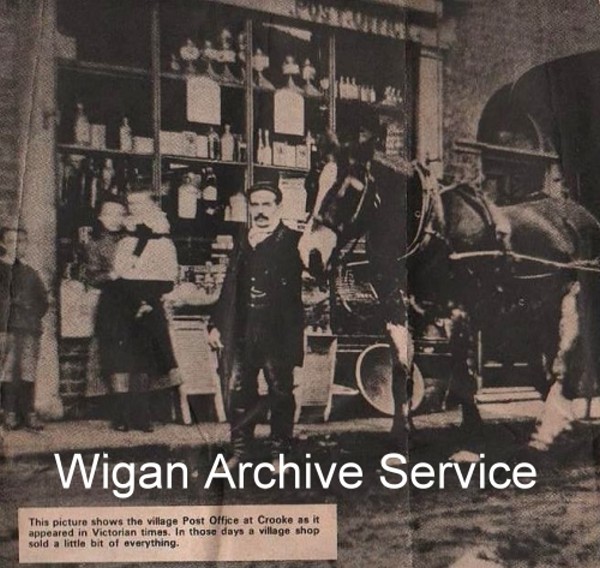
Houses which were the Crooke Hall Inn and The Duncan Arms. As it happens, I do have a picture of the Post
Office and one of one of the old bakeries.
Of the people living in the village, they too had a wide range of capabilities. Within that number, there were
jobs held which included around 180 associated with the coal mining industry, there were 6 Blacksmiths, Oil Works
Labourers, engine Men, Shoe Makers, Factory Workers, Safety Lamp Makers, Lamp Cleaners, Provision Dealers, Engine
Cleaners, Firemen, Clog Maker, another shoe maker, a Stoker for a Pit Engine, Sewing Machine Workers, a Carrier,
a Colliery Machine Clerk, in this year, a Lamp Lighter named James Taylor, a farmer at Crooke Hall Farm, resident
and travelling Bargees, around 92 of them, Stable Lads and Pit Lasses, a Taylor and two pub landlords. Everyone
turned their hand to something, even the children.
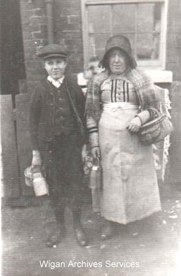
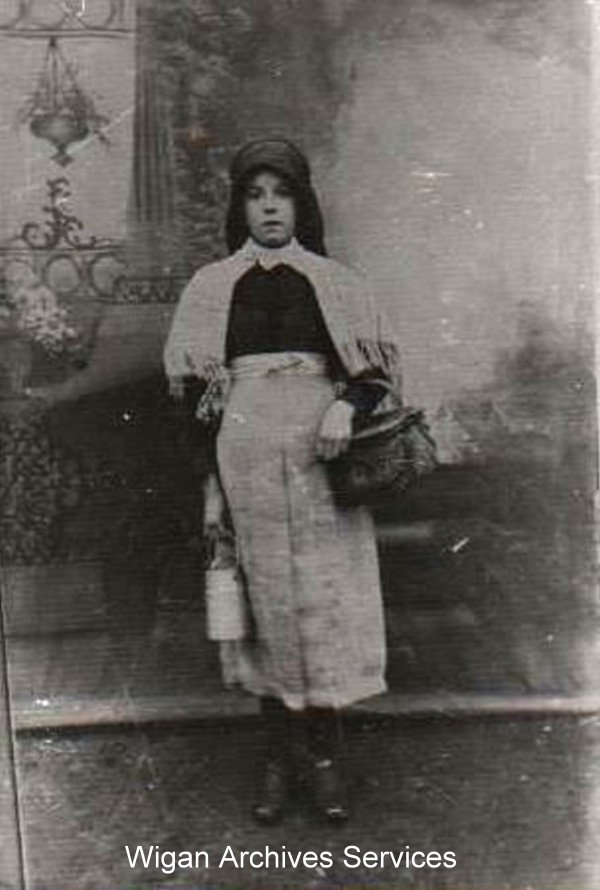
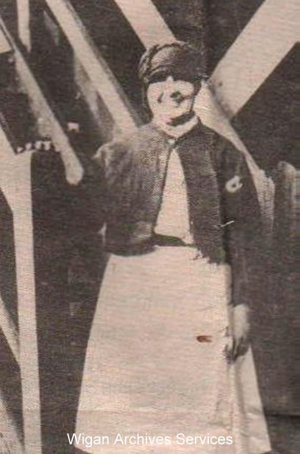
As it happens, I also have a couple of pictures of a bargee couple and a couple of pictures of pit lasses dressed
in their usual every day clothing which may give you an idea as to how people were dressed in those days?
Some children worked in the mills although I do not know if any of the Crooke children did but I can
tell you that the schools tried very hard to keep the pupils in school. Because families were usually large, it
meant that there were so many mouths to feed and as a result, everyone usually worked at something because the
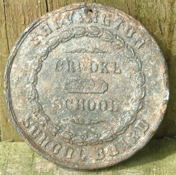
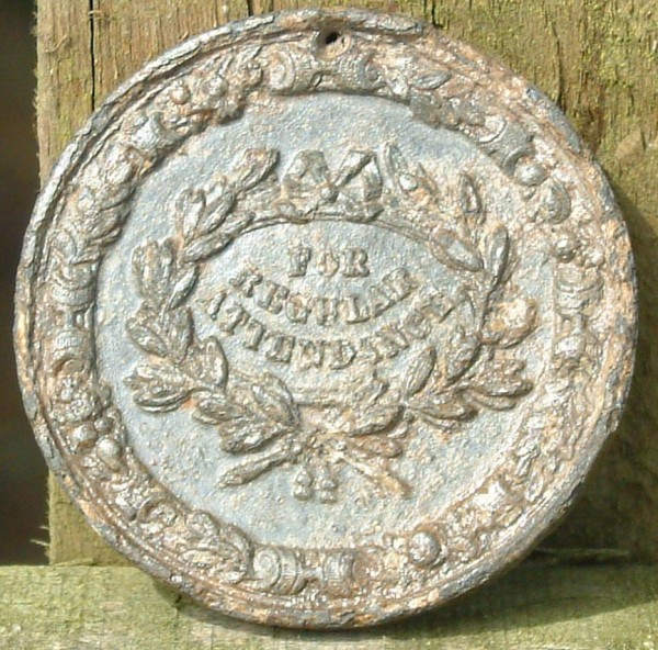
families needed the income. Schools encouraged parents to let their children stay in school and if their attendance
record was good, then the pupils would be rewarded. Their award came in the shape of an large coin with the words:-
'For Regular Attendance' stamped upon the medal. Fortunately for Crooke, such a medal has been found but it is not
known to who the medal belonged, but it shows at which school this pupil attended and in what year, in our case
1897.
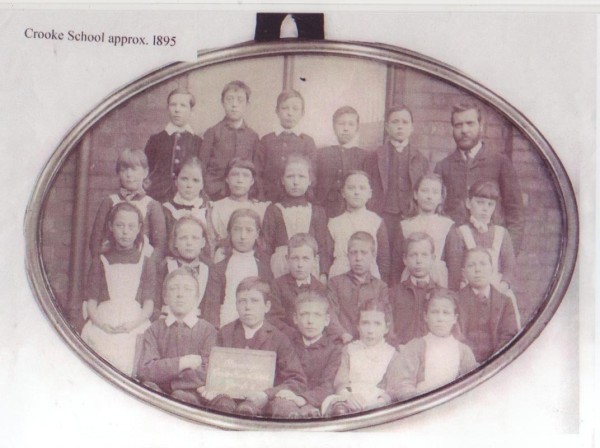
Now, I do not have a class picture that was thought to have been taken in 1895 but could have possibly been taken
later than that, maybe even in 1897? If that was the case, one of these faces could have been the recipient of the
above award?
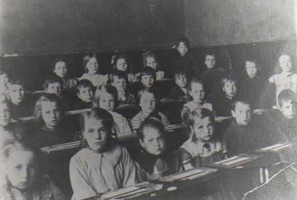
I have a few more class pictures, the next, dating from 1900.
1901.
In this year, according to the census, the village population reached its highest number, that being 624.
The census for the Crooke Hall Inn for this year makes interesting reading. The Landlady was a Mary Ann Barton aged
50 years who is a widow. Within her resedency, she has three Sons, a Daughter, an Uncle, one
servant and one visitor, probably a paying guest?
Her eldest Son was Thomas, aged 21 years, who worked as a labourer in a Chemical Works, maybe the one in Crooke? Her
second Son James, now aged 18 years, was an Engineer Planning Machinest. Margaret, her Daughter, now aged 16,
was a house maid and Mary's last Son, John, now aged 14 years, had a job as a Wagon Greaser. The Uncle, who's
name was Lambert Shepherd, aged 59 years, was a colliery labourer. The servant was a Thomas Bridge, aged 62
years, and was employed as a Stable Man and finally, the visitor, a William Watkinson, aged 72 years, was employed
as a farm labourer.
Across the road in the Duncan Arms, the licensees were Henry and Elizabeth Fairhurst, both aged 25 years who had
two Daughters, Edith, aged 3 years and Polly, aged 1 year. There were two others resident, a Jane Glover, aged 19
years who was employed as a Domestic and a Robert Greaves, aged 43 years who was employed as a Barman.
This is also the same year when the Bargees were given the opportunity to take up residence in one of the houses
already built in the village. I am unaware of the reason why the offer was made but I can tell you that all bar seven
took up the offered residences in Woodcock Row. Most barges were company owned so the bargees paid a rent for their
boat so the offer of a residency must have been a welcome chance to set up home on land.
1911.
In this year, according to the census, the population of the village had decreased to 543.
The Landlady of the Crooke Hall Inn continues to be Mary Ann Barton, now 60 years old. Her Sons, James, 28 years and
John, aged 24, are still in residence there. She now has two servants, an Ellan Robinson, aged 16 years and a Robert
Greaves, aged 43 years, who is employed as a servant and as a Stable Porter. The Uncle, Lambert Shepherd is still
in resedence, now aged 70 years who is now employed as a Locomotive Engine Cleaner.
Meanwhile, over at the Duncan Arms, The Publican and Minder is a Mr. Thomas William Pinder, aged 29 years and his wife
Mary Jane, aged 32 yeqars and they have one servant in resedence, a Dorothy Bentham aged 21 years.
The only other place mentioned in this years census is Crooke Hall Farm. It registers the head of the house as a John
Thomas Martlew, aged 23 yearsand he is noted to be the Teamater on Farm. John has four Sisters and one Brother all in the
same residence. Sarah Ethel Martlew, aged 21, is a dairy worker, Clara Alice, aged 19, is a School Teacher, Wilfred Harry,
aged 16, is a Cowboy on the farm, Lois, aged 15, also works on the farm and Sister Emma, aged 10, is a scholar.
Here is another school picture taken in 1913.
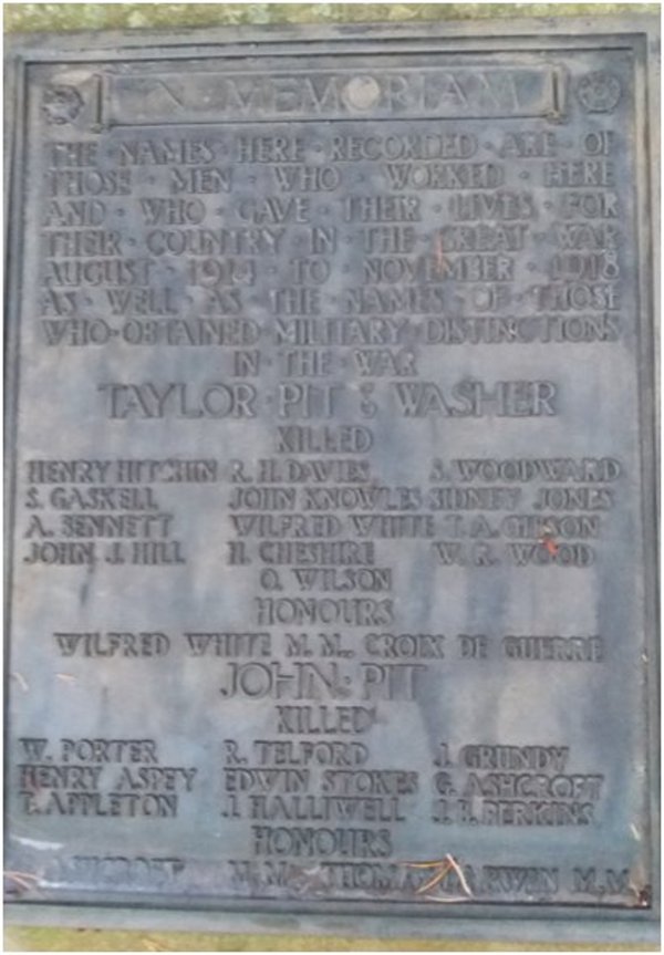
1914/1918.
During the 1914/18 First World War, coal production continued as normal. I have no reports of anything different.
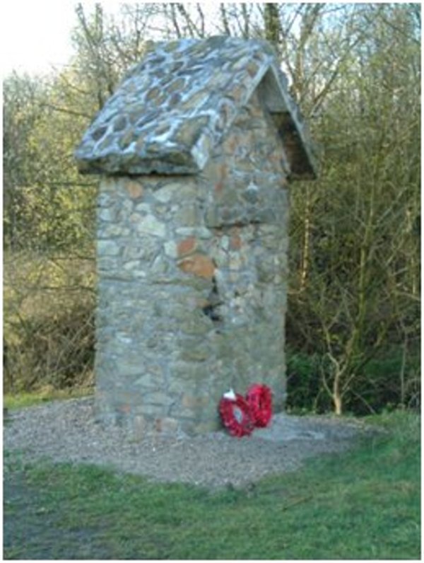
As a result of that First World War, a memorial stone was errected in Shevington to comemorate their service to our country and their loss
while in action. Of all the names of those killed in action, three were from Crooke. The memorial stone was errected probably in 1947
but the names were not added until later.
The stone was dedicated in 1954. The three named are:-
John Grundy The 1911 census records a 12 year old schoolboy called John Grundy. His father was a captain of a Canal Barge, working for
the canal barge company. John lived at 17 Woodcock Row cottages Crooke. He was born in Bootle. His father was from Wigan and mum from Parbold.
She had 9 children. By 1911 she had lost 4 of her children. In the CWGC records there are five J. Grundys who died between 1917 and 1919 but
whose ages are not given. John could be any one of these, and he would have been the fifth child of the family to die young.
Further information from Bernadette Green:
John Grundy, private, 28327, 4th battalion, Grenadier Guards, was born in Crooke in 1898 to James and Sarah Grundy who were boat people and lived
in Woodcock Row for a number of years. John was unmarried and joined the Grenadier Guards. He lost his life on 15th December 1917 at the battle
of Cambrai - he was 19 years old. He was the great uncle of Bernadette Green who supplied this information. The Commonwealth War Graves Commission
does not know his age. John is buried at the Le Cateau Military cemetery, approximately 27 kilometers east-south-east of Cambrai.
John James Hill, 20, was a stoker, 1st class, aboard HMS Hampshire, who died on 5th June 1916. The ship was carrying Lord Kitchener who was going
to Russia to seek help for the war effort. The ship was sunk by a torpedo or a mine, and only 12 men survived. John was the son of Richard and
Mary Ellen Hill, of 31, Moorfield Houses, Crooke, and is remembered on the Portsmouth Naval Memorial.
John Marshall. There is a very large number of John and J. Marshalls. However, this could well be Private John, of the Kings Liverpool Regiment,
born in Skipton, Yorkshire, who died, aged 33, on 20th September, 1917. He also is remembered at Tyne Cot, and he probably died during the Battle
of Passchendaele. John is recorded as the son of James and Jane Marshall, of 47, Crooke, Wigan, and husband of Elizabeth Ann Marshall, of 55,
Crooke.
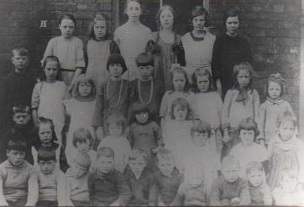
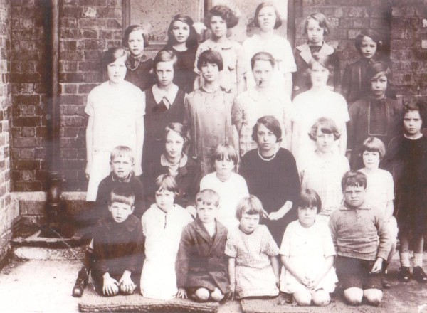
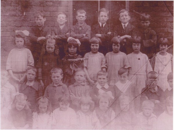
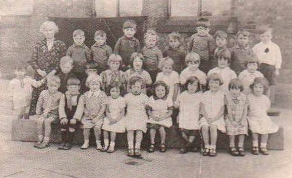
In keeping with the order of progression, I have another nine Class pictures taken at Crooke School between 1919 up to
1933. Of all of these pictures below, there are two, one taken in 1927 and the other in 1933 that I have pupil names for. See below.
1919.
1922.
1922.
1924.
1927.
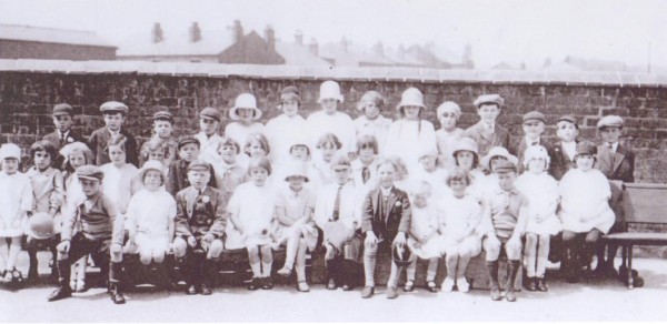
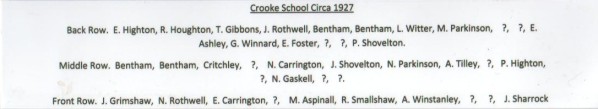
1927.
I do not have all of the names of the pupils in this class but here are those names I do have:-
Back:- Bentham, M. Foster, H. Tyrer, M Banks and M. Gaskell.
Middle:- E. Hill, J. Ball, M Bentham, H. Shovelton and E. Gaskell.
Front:- J. Foster, Bentham, S. Ball, C Grimshaw, M. L. Rankin.
Forward:- S. Bropwn, Grimshaw, T. Foster, Bentham, T. Brown, ?? and J. Shovelton.
1928.
1932.
1933.
I have an incomplete list of the pupils for this class photo. From left to right back row they are:-
Colin Jackson, Mrs. Smith, Charles Wilkins, Stanley Grimshaw, Jack Blackledge, Laurence Marshal, James Gibbons,
Thomas Houghton, Derek Robinson, Edward Thomas, Stanley Fairclough, Albert Garvin, Leslie Melling, Mary
Stonehouse, Betty Priestley and Betty Ball.
All these names were recalled by Stanley Fairclough who is one of these faces in this picture. The picture was
taken on the 1st of August after Stanley had attended his father's funeral at St. Anne's Church in Pemberton.
Stanley is the boy on the top right hand side of this picture. Stanley's father died of kidney failure at the
age of 29 years.
1936.
Memories of an ex Crooke resident, Harry Barker.
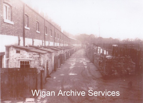
Harry Barker was born in 1930, one of seven children who in 1936 moved, with his family into No. 25 in Woodcock Row. Woodcock row had been built
over a two year period between 1856 and 1858 primarily for the influx of people who moved into Crooke so they could find work in the pits where
work was plentiful. Harrys dad worked as a stoaker, engineer and dealt with all steam engines and associated equipment on the surface, like
winding gear, static engines plus plus.
Harry, at the age of 14, started work at Giants Hall colliery on the surface. In 1947, he then worked in John Pit following on the Shevington
Hall Drift which was connected to John Pit by an underground tunnel. When those two pits closed in 1961, he then moved on to Robin Hill Drift
mine where the Almond Brook Hotel now stands and when that closed in 1962, he went on the Bold Colliery in St. Helens. In 1978, Harry suffered
a heart attack and when he recovered, he changed jobs and began to work at The British Glues & Chemicals work in Appley Bridge which changed
hands and became Croda until around 1995 when he retired.
Mr Barker now in his 80s, lives near to Crooke, in Princess Road with his wife Brenda and while talking to him about his life in Crooke, he
was able to recall the names of most of those then living in Woodcock Row.
The houses were numbered 1 to 26 heading away from the village which I suppose was in an unusual direction but there it is. Bearing in mind
Harrys age, he has remarkably recalled almost everyone who lived in that row around of houses between the years of 1936 to 1940. As you will
see from the listing below, here are the names of those who were then living in Woodcock Row.
1. Mr. Rigby (old chap), Nelley Sons Ned & Richard
2. Jones.
3. McGuigan, Girls Lucy, Molly, Ruth, Sarah & Helen, boys Brian & Stuart
4. Ned Peet & kids Ned & Martha
5. Robinson , Arthur & 1 girl
6. (Shop) Joe & Elizabeth Thomas, Joe, Susie, Teddy, Gerald &?
7. Dicky Martin
8. Ellen Hesketh, Joe Rigby, Billy (Brad)
9. Matt Rothwell, Nelly
10. Mitchell family
11. Jack Houghton wed Mona
12. Richard Cullen (Uncle (Mums Brother))Mary, Elizabeth & Roy
13. John Rigby & son John & girl Maggie
14. Tommy Carrington
15. Sam Gibbons & Martha, Sam, Jimmy & Sheila
16. Sam Gibbons (Father to No.15) Tom Catherine (wed a Cox from Beech hill
17. Jimmy Grundy lived with his old mother
18. Elizabeth & Frank Cullen, May, Maggie, Lizzy, Francis, Ada, Jimmy, Richard & Tommy
19. Gibbons (Bro to 17), John, William, Maggie, Liza, Lizzy, Margaret, John, Billy, Eric, Roy & Ken
20. Joe Thomas & Maggie (Alberts Mum) Irene, Betty, Berty, Billy, Albert & Margaret
21. Pemberton John, William Peggy & Agnes
22. Ben Foster & wife
23. Jacky Darwin & wife
24. Harry Butts Harry & Brenda
25. Henry and May Barker, Harry, Eileen, June, Ethel, Ada, James & Ann
26. Sam Bridge, Joe, Elias, Agnes & Bob
Bargees were now living in house numbers 9, 14, 15, 16 & 26 but the majority of the tenants who lived in Woodcock Row were employed as miners.
1937.
In the later life of Crooke Hall, it had changed hands many times and it had also become a collection of dwellings
all under one roof. It was devided up into five cottages but with the advancing water problems, it slowly deteriated.
Here is another pictures of the hall taken in 1900 and one as it fell into disrepair.
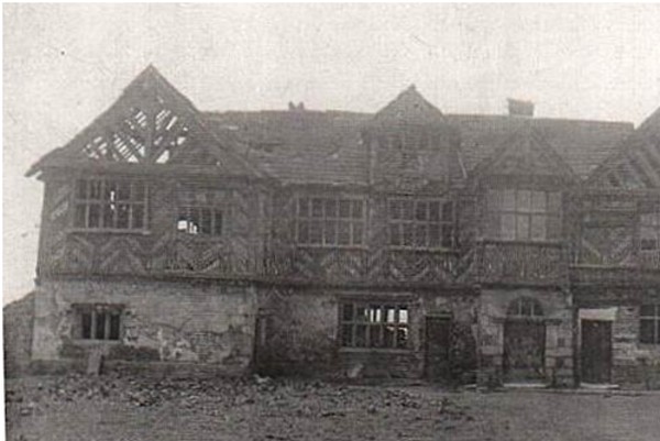
As a result of the coal mining in the area, Crooke Hall began to sink into the ground as had the Mission school before
it because of subsidence. By the time of the First World War, the building had become half submerged and by the 1920's,
the water level had reached well under the upper storey making it making it unfit for human habitation and as a result, in
1937, the building was demolished.
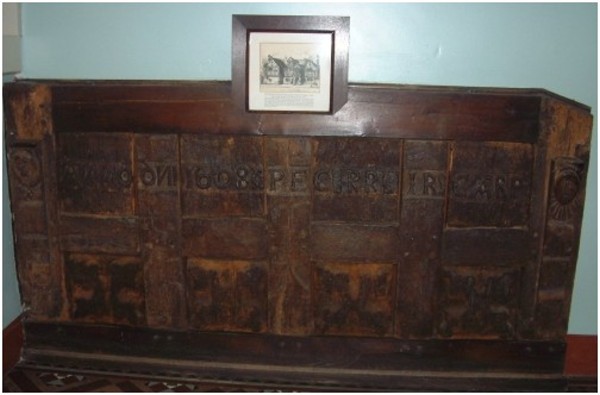
During the construction of the hall, the builders calved an inscription into a wooden beam situated above the front door
of the property. The inscription reads:- ANNO DNI 1608 PEC PR IR CARP. Breaking in down, it reads anno domini 1608,
PEC for Peter and Elizabeth Catterall and the PR and IR, possibly Brothers, were the initials of the builders of their Hall
but unfortunately, I do not have their names and CARP denoted Carpenters.
When the Hall was demolished in 1937, the last owner of the Hall was a James Lyons, who, then living in Shevington, presented the
heavy oak panelling from above the front door of the hall, to the Library in Wigan as a memento. Today, that heavy oak
panelling can be found at the foot of the stair well inside the History Shop that leads to the first floor.
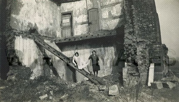
I have one picture that was taken during the demolition of the Hall showing a couple of local girls standing in the shell
of the building. One being Mary Ann Aspinall who I think is wearing a dark skirt but I do not know who the other girl is/was?
If you think you know who she is/was, perhaps you might like to let me know?
Ironically, in 1951, the Hall was scheduled as a building of historical and of architectural interest by the Ministry of
Works and worthy of preservation and had a grade II listing placed upon it, but it was 14 years too late because, by the time the
ministry came to realise their wish, the Hall had already been demolished.
Two years later, the Second World War happened and business carried on as usual with an increase of production to meet demand. After the war, everything
settled down again, the government changed a few times until Maggie Thatcher came into power. The miners in general around the country were striking for
better pay and conditions and because our Prime Minister did not want the miners to hold the country to ransom, she decided it was going to be the end of
coal mining in the main, in this country. (I do not usually make political comment but think it relevant here)
1943.
Where possible, I will add more personal snippets like this one. I have been communicating with Brian Grundy. He tells me his Mother and Father were
married in Crooke in May 1943 during the war and he believes the name of the minister who took the wedding was Ayden Phillipson. He sent me a couple of
pictures of the happy couple so here they are:-
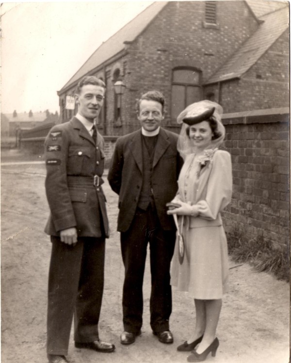
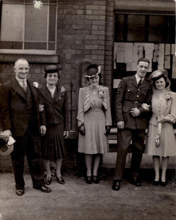
You will also find these pictures on the Crooke in 1978 plus others page. He also informed me that his mum, then aged 7 in 1927 is in the Crooke class
picture of that year and then, she was Minnie Aspinall, again, already posted further back.
1939/1945.
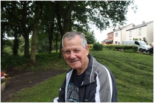
In 1945, Bill Hart, then aged 14, for three years worked as a weigh bridge clerk on the tip at Crooke. Bill, now 85, lives in Shevington.
All this came about because over the last few days, July 21st through to Sunday the 24th, 2016, work in the village of Crooke has unearthed the header wall
and foundations of the rear of the tip assembly still in situe after being buried for over 50 years. The tip closed in 1961 and everything, we thought, had
been removed only to find, like the buried rail track under the tarmac in the road, parts of the tip foundations are still there. As a result of the finding,
Gordon Banks, a local builder who has lived in the area all his life, knew of Bill and was aware that he used to work on the tip in Crooke and so asked him
to come to Crooke to tell us his tail.
He told us how the delivery system worked, coal coming down from John Pit, where the trucks were uncoupled, how a horse was used to help move the trucks,
trucks were weighed and then, if necessary, turned around because only one end of the truck would open so they had to be the right way around. One of the
two metal gate pins was removed and replaced with a wooden peg before the other pin from the other side was removed. The truck would then be moved slowly
with the aid of a pinch bar under the wheels and the truck would be inched into the tipping position. Once there, it would be tipped and the weight of the
coal in the truck would break the wooden peg allowing the tail gate to open letting the coal to fall out of the rail truck, slide down a shoot and then fall
into a waiting barge. There were usually five trucks that were delivered from John pit and the loco never brought them down all the way.
1948.
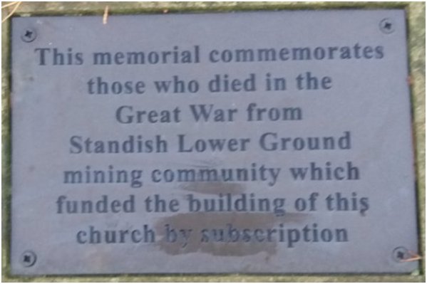
At the end of the Second World War, once again, those soldiers who died are commemorated on the same plaque as those of the First World War and those
remembered from Crooke are, James Lamb and John McNamara.
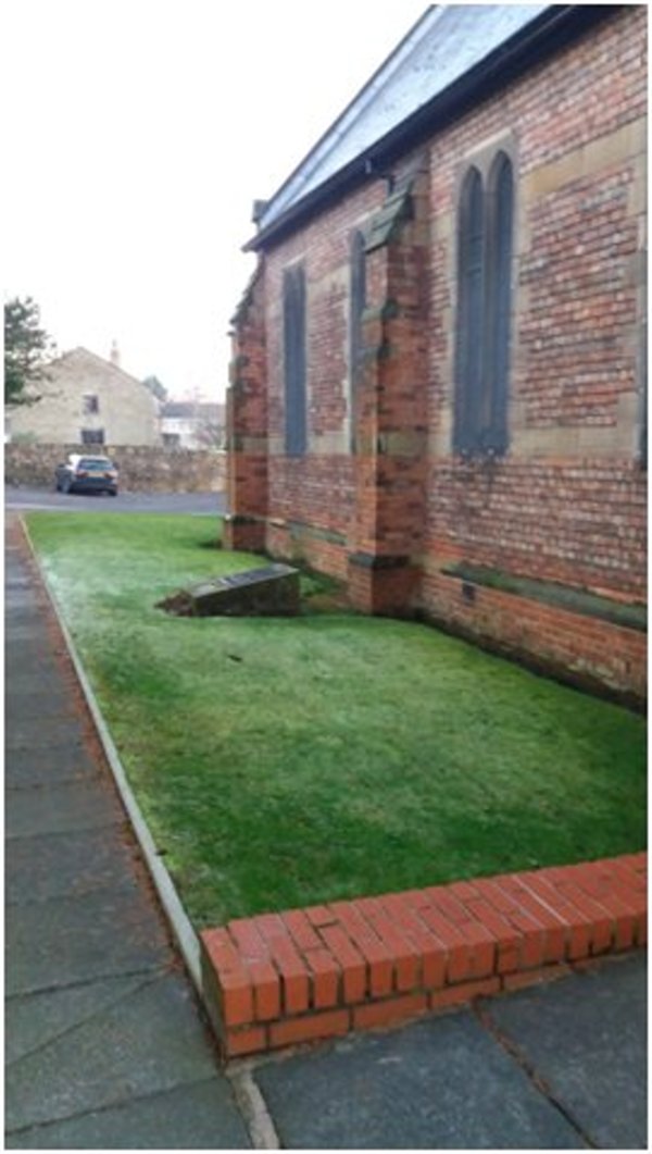
As a result of vandalism and theft of the plaques for their metal content, replacements were made and were then resited outside of St. Anne's Church in
Shevington.
1961.
In 1961, all the local working pits near to Crooke, closed, those being, John Pit, Shevington Hall Drift Mine, Taylor Pit and Giants Hall Colliery. Over the
next two years, the whole landscape of Crooke was to change. The Crooke Tip/Tippler was demolished, the rail tracks were taken up, The slag heap that used
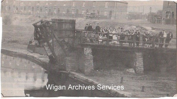
to be on the green between the village and Wigan Lower Road, more commonly known as the Rook was taken away and in 1963, Red Bridge the rail bridge that
spanned Wigan Lower Road to John Pit was also demolished. The cutting that had been built to house the rail lines that came into Crooke were also filled in,
probably with some of the spoil from the Rook, so what was once a bustling and busy community, suddenly fell silent. It was also the death Nell for the
bargees because there was no coal to move and there was no substitute business to sustain them, so most finished and the canal was almost abandoned.
1966.
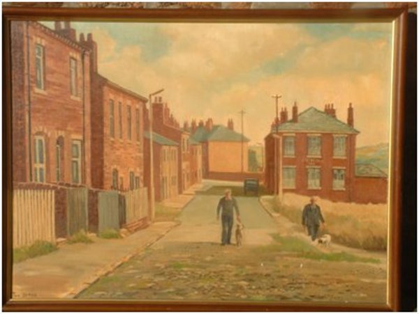
I am to believe that the five houses that stood between where the rail tracks were to the opposite diagonal corner to the Crooke Hall Inn or next to the road
near to house number 81 opposite the pub were demolished. They were considered too poor for habitation. This painting is the only copy of the buildings
that used to stand there, painted by Tom Byrne.
1972/1973.
In the early 70s, a Mr. Tommy Halsall bought the farm house and made an effort at digging some ground out with the view of building a marina but that never
really came to much and it is thought he gave up. Tommy died and George, his son inherited the farm house.
1972/1978.
It was around 1972 when the council informed the village that they were not going to plough any more money into the properties within Crooke because they
considered them to be substandard and not worth the extra expense. In 1975, the village was informed that it had been listed for demolition and needless to say,
the residents were not happy with this decision and decided to do something about it. Advice was sought and it was decided the village needed to create a
Co-operative. It was discussed and agreed that members who joined and sold their houses to the co-op would, in turn, receive a grant, given by Wigan council
to undertake necessary repairs. The co-op was formed in 1978 and dealt with all lettings and other property maintenance which it did up until 2008.
1985.
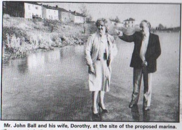
In February 1985, John Ball, a business man who was a supplier of building materials, submitted plans to Wigan council for the construction of a marine which
would be situated at the far end of the village and be built in the area where Woodcock row use to stand. There were many objections raised by the villagers
because it was thought the road would not sustain the heavy wagons that would be needed for the construction passing through the village. Even after all the
complaining, permission was granted so the construction of the marina could go ahead.
In September 1987, Dr. David Bellamy added his weight to the protest against the proposed marina and invited the town of Wigan to object also.
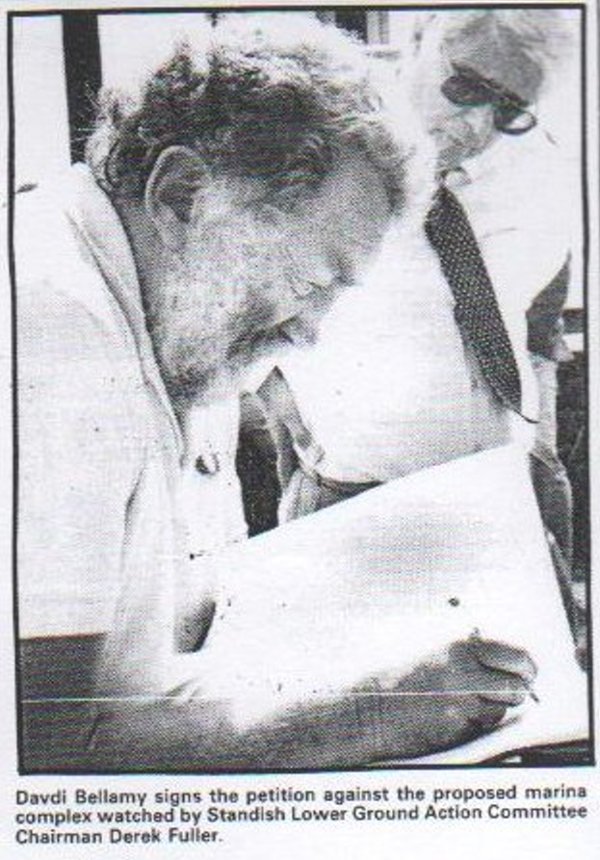
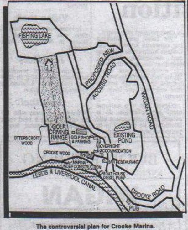
By January 1989, building work had not yet begun on the proposed marina before Mr. Ball submitted an alternative proposed plan, reudcing the size of the park
and adding a far larger project, a Golf driving range, a fishing Lake, shops, Bar and restaurant, overnight accommodation and a new access road which was
designed to go through Lawns wood which the council had recently bought to protect the wild life and the rare Split Willow growing in there. This time, the
council refused his plans and turned him down. He had threatened to open cast for coal if his plans were denied but thankfully, that did not happen.
1978.
After the pits closed down, Woodcock Row fell into disrepair and over the years continued to reduce in size until in 1978 when the last three houses were
demolished.
There is now a sizable gap in time because the next recordable event takes us to the years of 1996/7.
1996/1997.
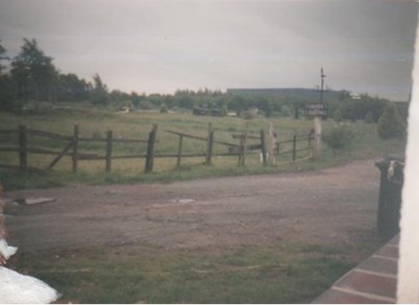
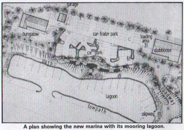
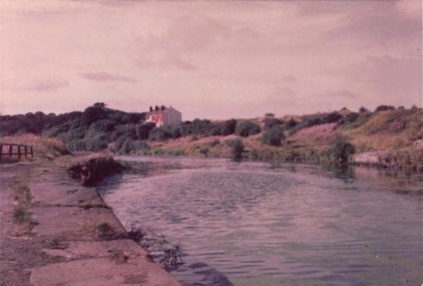
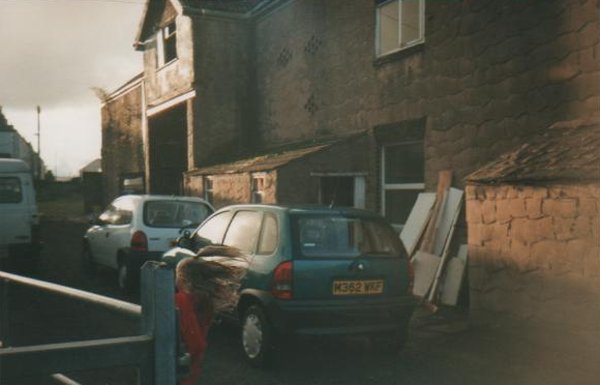
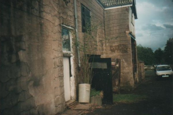
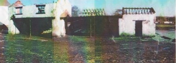
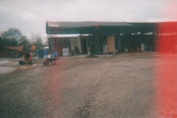
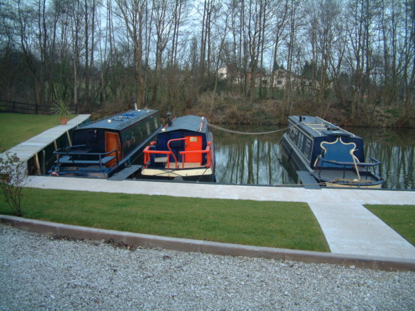
George Halsall sold the farm to Tracey Hibbot and the land to Roy and Yvonne Vernon and then the transformation began. Tracey modernised the farm house and
Roy and Yvonne began the rebuild the out buildings, built a bungalow for themselves to live in and then set about building a marina. I have a few pictures
of the beginnings of the changes.
Here are a couple of shots of the house at the start of renovation. <
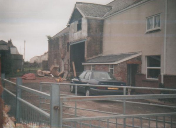
And now a few of the marina and outbuildings being renovated and the marina land prepared.
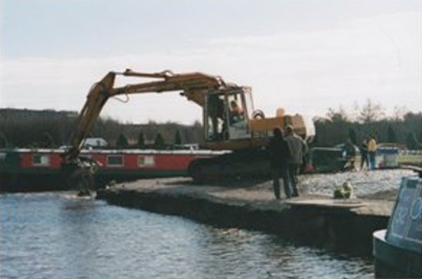
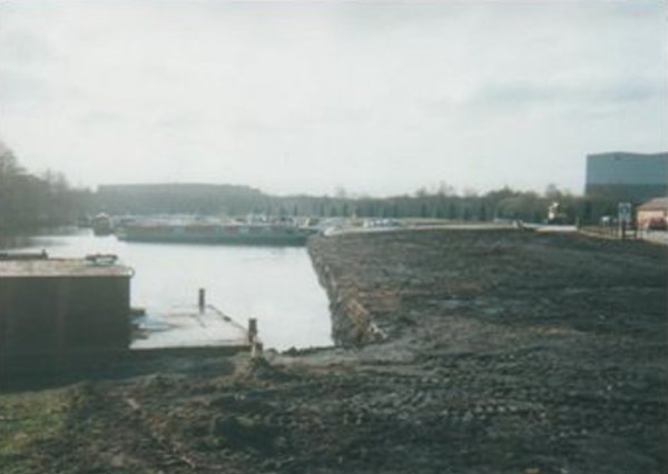
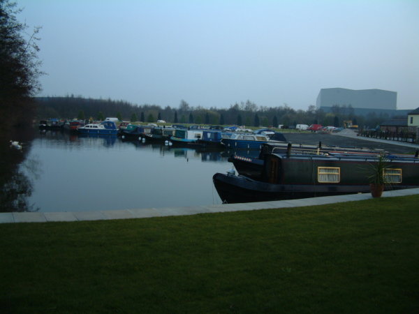
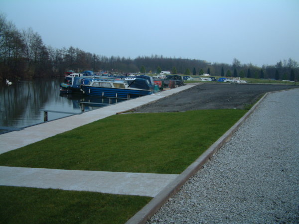
I took a few shots in March 2003 and the last two in 2006:-
2008.
2008 was the year the co-operative closed down. I will continue soon.
For the present, that is all I am posting today but there is yet more to come so, watch this space.
-oOo-
|
|
